Catalog Archive
Auction 136, Lot 297

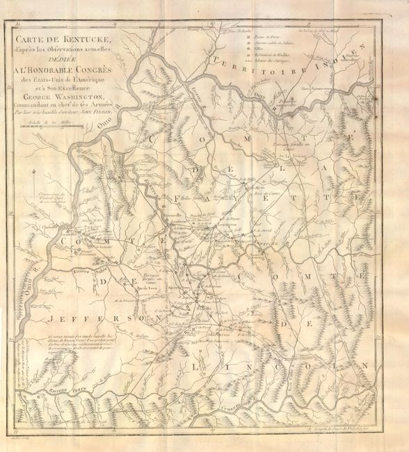
The First Map of Kentucky

"Carte de Kentucke d'apres les Observations Actuelles; dediee a l'Honorable Congres des Etats-Unis de l'Amerique et a Son Excellence George Washington, Commandant en chef de ses Armees", Filson, John

Subject: Kentucky

Period: 1785 (dated)

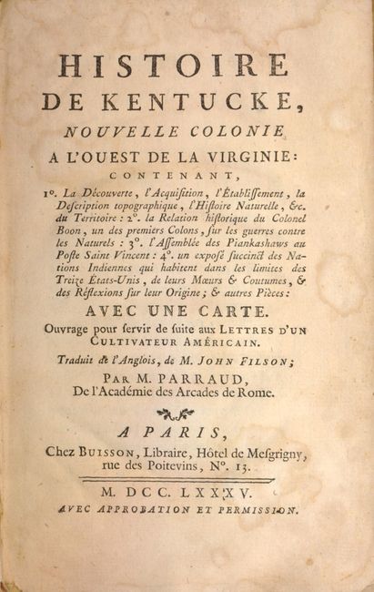
Publication: Histoire de Kentucke

Color: Black & White

Size:
12.3 x 13.5 inches
31.2 x 34.3 cm
Download High Resolution Image
(or just click on image to launch the Zoom viewer)

Filson's landmark and very rare map of Kentucky extends from the Ohio River in the north to the Cumberland River in the south. The map contains numerous notes on the topography and nature of the land and features a legend identifying forts, villages, mills, and even the "huts of savages" (Indian settlements). John Filson (1753 - 1788) was the first Historian of Kentucky. Moving from Pennsylvania about 1782, he settled in Lexington where he divided his time between teaching and surveying land claims. He wrote The Discovery, Settlement and Present State of Kentucke in 1784. The "Map of Kentucke" was engraved and printed in Philadelphia and was reprinted several times prior to 1793 but his plan for a second edition was not realized. He purchased land at the junction of the Ohio and Licking rivers, the future site of Cincinnati, which he named Losantiville. His survey and plan of the town is visible in the structure of today's downtown Cincinnati. In 1788 while on a surveying expedition near the Great Miami River, he disappeared when the party was attacked by Shawnee Indians.

The map is still bound in Histoire de Kentucke, Nouvelle Colonie a l'Ouest de la Virginie, which was translated into French by M. Parraud. The book contains a vast array of information on Kentucky, including the discovery, the acquisition, the establishment, and a description of the topography and nature. Also included is some history on Colonel Daniel Boon and the Native Indians in the region. Contains two lovely bookplates on the front pastedown: one from "Ex Bibliotheca Sobolewskiana" and a private one from Elizabeth Griswold Lane Moss, an Ohio notable. 234 pp., bound in mottled calf, spine gilt, gilt panels on covers, decorated endpapers, and ribbon page mark.

References: Howes #F129

Condition: B+

Map with light, uneven toning. In need of rebacking with warped back board and part of spine detached. Light damp stains at beginning and end of text block, with a small tear on p.99.

Estimate: $2,500 - $3,000

Sold for: $1,700

Closed on 6/1/2011

Archived