Catalog Archive
Auction 136, Lot 170

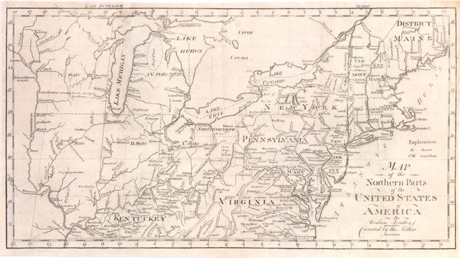
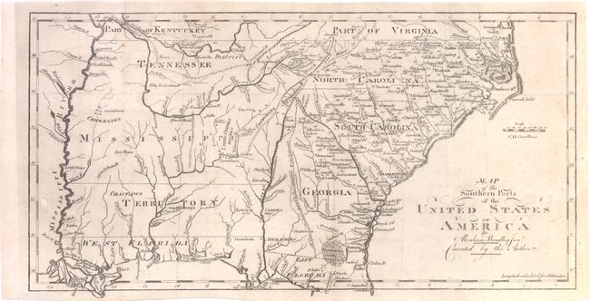
"[Lot of 2] Map of the Northern parts of the United States of America... [in set with] Map of the Southern parts of the United States of America…", Bradley, Abraham Jr.

Subject: Eastern United States

Period: 1802 (circa)

Publication:

Color: Black & White

Size:
See Description
Download High Resolution Image
(or just click on image to launch the Zoom viewer)

This pair of maps cover the young United States during the tumultuous period following independence when the states and central government fought over control of the western land claims. Seven of the 13 original states had claims to areas in the West (those lands between the Appalachian Mountains and the Mississippi River). These so-called landed states had a great potential advantage over the six landless states. It was assumed that the future sale of western lands would enrich the landed states and possibly allow them to operate without any form of taxation. The landless states feared that they would lose residents and dwindle into insignificance. The matter was further complicated by the fact that the claims often overlapped one another, which pitted one state's interests against another. Both maps are in their second states with "Corrected by the Author" below the title.

The map of the northern parts (15.8 x 8.5") shows the new states of Ohio, Indiana, Illinois, Michigan and Wisconsin that were proposed in the Ordinance of 1789 referred to, respectively, as State I, II, III, IV, and V. The northern boundaries of Illinois, Indiana and Ohio are shown at the southern tip of Lake Michigan. The positioning of this line later resulted in a boundary dispute between Michigan and Ohio, with Ohio blocking admission of Michigan to the Union until the question was settled. The mostly blank Wisconsin bears the notation "Large Meadows extending to Lake Michigan." Wisconsin came from the term "Ouisconsin" that is believed to mean "grassy place" in the Chippewa language. The remnants of several bounty land grants are shown including New Connecticut and Seven Ranges. Wayne County is the only county shown in Michigan. Cincinnati is here called Cincinnatus. The boundary line from Gen. Wayne's Treaty of 1795 is shown. The map extends to the Mississippi River with the lands to the west labeled, Re Lands Reserved by the US.

The map of the southern parts (15.2 x 7.7") shows much of present-day Mississippi and Alabama in Mississippi Territory, with the coastal region named West Florida. A dotted line running north-south through present-day Georgia demarcates "All West of this line is claimed by the United States & also by Georgia." The overlapping claims were resolved when Spain gave up its claim to West Florida in 1795 and Georgia finally relinquished its claim in 1802 (the last of the landed states to surrender its claim). Another interesting feature of the map is the notation of the number of men in several of the Indian tribes in the western territories.

References: Wheat & Brun #158 & 496.

Condition: A

Issued folding, now pressed. Several short fold separations expertly repaired. The northern map has a tiny tear in the top right margin.

Estimate: $550 - $700

Sold for: $400

Closed on 6/1/2011

Archived