Catalog Archive
Auction 136, Lot 161

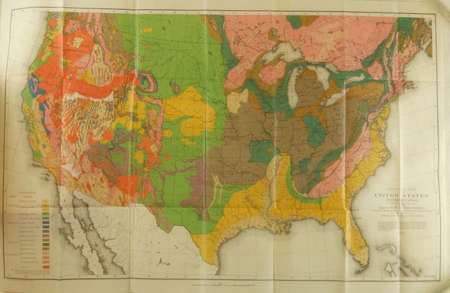
"Geological Map of the United States and Part of Canada Compiled by C.H. Hitchcock for the American Institute of Mining Engineers to Illustrate the Schemes of Coloration and Nomenclature Recommended by the International Geological Congress", Hitchcock, Charles Henry

Subject: United States

Period: 1886 (dated)

Publication: American Institute of Mining Engineers International Geological Congress

Color: Printed Color

Size:
27.8 x 17.3 inches
70.6 x 43.9 cm
Download High Resolution Image
(or just click on image to launch the Zoom viewer)

This remarkable map and report provide the first complete geological picture of the entire United States. This claim was made by Hitchcock in his article, "The Geological Map of the United States" in volume XV, of the Transactions of the American Institute of Mining Engineers, 1886-1887. This lot includes the original report with the map still bound in. Hitchcock writes (p. 468): "For the first time in the history of American maps it has been possible to show the distribution of stratigraphical divisions of equal importance in every part of the country." Hitchcock describes the 1884 McGee, U.S. Geological Survey national map as incomplete: "Because of the scarcity of existing and available information, it became necessary to leave the following States and Territories either partially or wholly uncolored: Arizona, California, Idaho, Montana, Nevada, New Mexico, Oregon, Texas, Utah, Washington." In the section listing the improvements in his (Hitchcock's) map, he notes: "2. Extension of the colors into the States and Territories of the far West," and he gives the sources for the new information that allowed him to fill in the western states.

This large chromolithographic map provides terrific detail of the geological formations of the country. It extends to the adjacent parts of Canada, but the focus is clearly on the United States. An explanatory key to the colors indicates sixteen geological formations, increased from nine shown on the first edition of 1873. The carefully drawn map shows good geographical detail as well as remarkable geological information. Lithographed by Julius Bien on fine banknote-style paper. An important and landmark geological map.

This book contains 64 papers on various mining-related topics which, in addition to the Hitchcock paper, include significant papers and maps on the geology and vein structure of southwest Colorado (San Juan Mountain region) by Theodore Comstock, and the silver mines of Calico, California, by Waldemar Lindgren. Complete with several folding plates including Sketch Map of the Clifton Mining District, Arizona; design plans for a "Sectional hanging Pipe Hot Blast Oven"; Orographic Features of Southern Colorado, Showing Boundaries of Mineral Zones; Geological Map of S.W. Colorado; Map of the Central San Juan Area, with the Red Mountain District and the Rico Tract"; Map of the Oil & Gas Fields in McKean & Elk Counties, Pennsylvania; Sketch Map of Calico District, San Bernardino, Cal. And a few others. All folding maps are printed on fine bank-note style paper. Hardbound in original half maroon leather and marbled boards with gilt title and raised bands on spine. This map is rarely offered complete with the source report.

References:

Condition: A

Map is fine with clean bright impression and very strong color. The book has some shelf wear to binding including light abrasion to raised bands and edge of spine, one folding plate mis-folded with split.

Estimate: $500 - $650

Sold for: $1,100

Closed on 6/1/2011

Archived