Catalog Archive
Auction 136, Lot 139

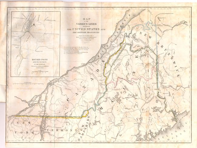
"Map of the Various Lines between the United States and the British Provinces", Graham, James D.

Subject: Canada & New England

Period: 1846 (dated)

Publication: Mr. Webster's Vindication of the Treaty of Washington in 1842…

Color: Hand Color

Size:
15.5 x 11.8 inches
39.4 x 30 cm
Download High Resolution Image
(or just click on image to launch the Zoom viewer)

The finely engraved map shows the disputed borders and border treaties between the United States and Canada. The map is centered on Maine and includes parts of the surrounding New Brunswick, New Hampshire, Vermont and New York. Hand coloring identifies the Boundary Established by the Treaty of Washington of 1842; Line by award of the King of the Netherlands; and Line claimed by the U.S. under the Treaty of 1783. Also shows the true Meridian Traced by Major Graham. This is an edition we've not previously encountered that moves the title slightly to the right with a new line below concerning the Highlands in Maine. To the left is added an inset map showing detail of the Canadian/US boundary at the outlet of Lake Champlain. This map, "Rouse's Point and its vicinity on Lake Champlain Shewing the positions selected for the Fortifications" (4" x 6"), shows a massive "site of proposed fortification" on the New York side and a fort on an un-named spit of land later called Island Point. This un-named fort is the infamous Fort Blunder that was built on an unstable foundation and abandoned uncompleted after two years of construction at a cost of approx. $200,000. Originally thought to be south of the 45th degree of latitude, a later survey found it to be about two-thirds of a mile north of the border (clearly seen on the inset map). As seen on the inset map, the Treaty of 1842 moved the boundary about one-half mile north of the fort. The proposed fort was eventually built and called Fort Montgomery, with part of its massive walls still remaining today.

The map is still bound in the original 64-page report, "Mr. Webster's Vindication of the Treaty of Washington in 1842… In 1838 Canadian lumberjacks illegally entered the United States to cut timber in the Aroostook region during the winter months. They seized the American land agent dispatched to expel them, thus starting the Aroostook War. After Maine dispatched 10,000 troops to confront the Canadians, President van Buren sent General Winfield Scott to the "war" zone. Scott arranged an agreement between officials of Maine and New Brunswick that averted any actual fighting. The dispute was settled in 1842 by the Webster-Ashburton Treaty, also known as the Treaty of Washington as it is named on this map. Political opponents later accused Daniel Webster, the lead negotiator, of giving too much land to the British. This report is Webster's answer to these criticisms and it is an excellent summary on the negotiations with extensive references to correspondence.

References:

Condition: B+

The map is sound with some scattered foxing and a tiny insertion tear in the border. The disbound report has a little light text offsetting in some areas, but is generally clean with no physical flaws.

Estimate: $400 - $600

Sold for: $300

Closed on 6/1/2011

Archived