Catalog Archive
Auction 136, Lot 115

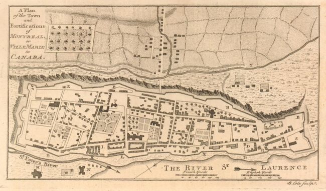
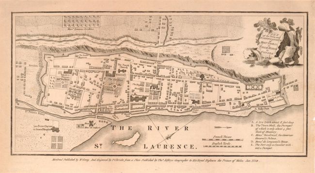
"[Lot of 2] A Plan of the Town and Fortifications of Montreal, or Ville Marie in Canada [and] Plan of the town and Fortifications of Montreal or Ville Marie in Canada in 1758", Anon.

Subject: Montreal, Canada

Period: 1758-1839 (published)

Publication:

Color: Black & White

Size:
7.5 x 4.5 inches
19.1 x 11.4 cm
Download High Resolution Image
(or just click on image to launch the Zoom viewer)

A) A Plan of the Town and Fortifications of Montreal, or Ville Marie in Canada, from the Grand Magazine of Magazines. This rare and detailed plan of Montreal is taken from Jefferys map of 1758. It delineates the small town built between the St. Laurence on one side and steep cliffs on the other. The surrounding fortifications, individual buildings and streets are noted, as are the cultivated fields above the cliffs. Many buildings are keyed A-Y and relate to the article The Importance of Montreal in the December 1758 issue. The map was engraved by B. Cole. Ref: Jolly GMOM-14. (A+)

B) Plan of the town and Fortifications of Montreal or Ville Marie in Canada in 1758, published in the Hecla Depicta: The Early History and Present State…of Montreal, 1839. It very similar to the map published in the Universal Magazine in 1759, except the cartouche has moved to the upper right and "in 1758" added to title. Another difference is the key, which here lists only five places/buildings compared to the Universal Magazine edition that has over 20 listed. Below the neatline is "Montreal Published by W. Greig, and Engraved by P. Christie from a Plan Published by Thos. Jefferys, Geographer to his Royal Highness the Prince of Wales. Jan. 1758." No engraver attribution given. A uncommon Canadian historical edition published in Montreal. Issued folding, now flattened. Full margins and nice impression (A).

References:

Condition: A

Estimate: $200 - $250

Sold for: $275

Closed on 6/1/2011

Archived