Catalog Archive
Auction 135, Lot 395

"Alla Serma Sigra Principsa. d'Urbino Granduchessa di Toscana sua Sigra D: Roberto Dudleo Duca di Northumbria", Dudley, Robert (Sir)

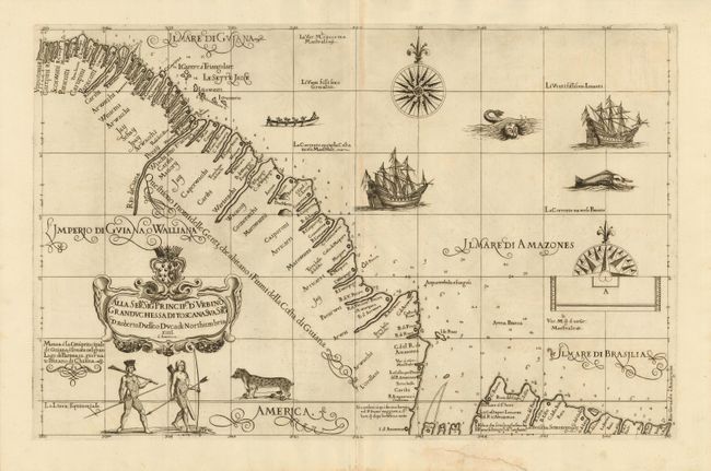
Subject: French Guiana and Brazil

Period: 1660 (published)

Publication: Dell Arcano del Mare

Color: Black & White

Size:
28.5 x 18.5 inches
72.4 x 47 cm
Download High Resolution Image
(or just click on image to launch the Zoom viewer)

This splendid chart covers the coast of French Guiana to just beyond the mouth of the Amazon River. One of Dudley' most decorative charts, it is adorned with fabulous engravings of ships, a native canoe, fearsome sea monsters, tattooed natives and a jaguar. His charts of this region were particularly decorative and detailed because in 1594 Dudley led an expedition to the Orinoco and Guiana. He then supplied Robert Thornton with charts for his voyage to the Amazon in 1607-08. In return Thornton supplied Dudley with information that was incorporated into this chart. This is essentially an untitled chart; the cartouche contains the dedication to Dudley's patroness, the Duchess of Tuscany. The distinctive calligraphy (alla cancellaresca), fine cartouche, and decorative elements are the work of the engraver, Antonio Francesco Lucini. Printed on two, joined sheets as issued.

Robert Dudley was the first Englishman to produce a sea atlas, Dell' Arcano del Mare (Secrets of the Sea). He introduced a totally new style for sea charts in the atlas with only lines of latitude and longitude and no rhumb lines. The charts were meticulously compiled from original sources and were both scientific and accurate for the time. This important atlas was the first sea atlas of the whole world; the first to use Mercator's projection throughout; the earliest to show the prevailing winds, currents and magnetic deviation; and the first to expound the advantages of Great Circle Sailing. In an introductory leaf found in one copy in the British Library, the engraver states that he worked on the plates in seclusion for twelve years in an obscure Tuscan village, using no less than 5,000 pounds of copper for the printing plates. It was only issued in two editions and the maps are rarely seen on the market. This map is from the second edition.

References:

Condition: A

Dark impression with some very faint offsetting. There is an old repaired tear in the bottom margin, not affecting the map.

Estimate: $2,100 - $2,500

Sold for: $2,000

Closed on 2/16/2011

Archived