Catalog Archive
Auction 135, Lot 322

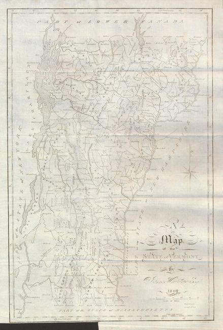
"A Map of the State of Vermont", Whitelaw, James

Subject: Vermont

Period: 1809 (dated)

Publication:

Color: Black & White

Size:
5 x 9 inches
12.7 x 22.9 cm
Download High Resolution Image
(or just click on image to launch the Zoom viewer)

This early and scarce map of the state details counties, towns and villages, waterways, lakes, and mountains. Scores of named townships are delineated and counties are named and located. Fancy titling and compass rose. This is the updated 1809 edition.

The map is in the original two volume The Natural and Civil History of Vermont in Two Volumes (Ref: Howes W478; Sabin 104350) by Samuel Williams, LL. D., printed by Samuel Mills in Burlington. This is an extensive history of Vermont by Samuel Williams. First published in 1794 this is the second edition, which in 1809 was greatly expanded and enlarged. The two volume set includes chapters on natural history, resources, climate, vegetable production (with a scientific discussion on the effect of trees on the environment), native Indians, and a history on early settlements. Also has socially related sections on the relations with the neighboring states, customs, government, and a historical look at the American Revolution. Hardbound in full leather, vol. I 515pp, vol. II 487pp, title pages, Preface, Contents, text, map.

References: cf Wheat & Brun #194 (1793).

Condition: A

The map is folding, as issued and lays at the front of volume I. The map is near fine with only a short tear at binding trim, closed on verso. The volume contents are good with some darkening in text. There is a split at front of spine on volume I, and some moderate shelf wear to include a small area of surface loss at lower right corner. Volume II covers have very light shelf wear and the front blank end page is missing.

Estimate: $300 - $500

Unsold

Closed on 2/16/2011

Archived