Catalog Archive
Auction 135, Lot 189

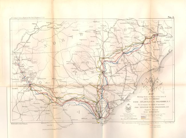
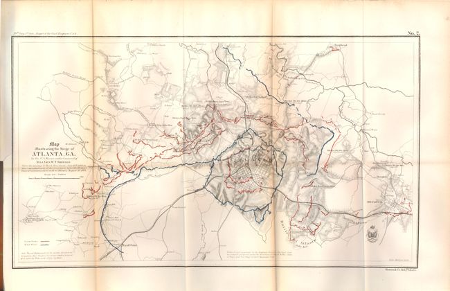
"[Lot of 2] Map Showing the Route of Marches of the Army of Genl. W.T. Sherman… [and] Map Illustrating the Siege of Atlanta, GA… under the Command of Maj. Gen. W. T. Sherman", U.S. Army

Subject: Southeast - Georgia

Period: 1864 (dated)

Publication: Report of the Chief Engineer, 39th Congress, 1st Session

Color: Hand Color

Size:
See Description
Download High Resolution Image
(or just click on image to launch the Zoom viewer)

The following two maps are complete with pages 1156 - 1218 of the disbound report to provide actual descriptions of the events from the leaders who initiated and prosecuted them. The maps together with these writings provide a fascinating study of these important Civil War battles. For example, on March 31, 1865 General Sheridan writes in his campaign of Atlanta "This force is too strong for us. I will hold on to Dinwiddie Court House until I am compelled to leave."

1. Map Showing the Route of Marches of the Army of Genl. W.T. Sherman from Atlanta, GA. To Goldsboro, N.C. (15.8 x 9.8"). This map provides a larger view of General Sherman's campaign to include the colored routes taken by the 15th, 17th, 14th and 20th Army Corps and the Cavalry. Not mentioned in the title, the map extends to show the Chattanooga to Atlanta operations, from May 5th to Sept. 4th, 1864, detailing in red and blue overprinting the Union and Rebel Works. Five battle maps representing each Army and the Cavalry are above the title.

2. Map Illustrating the Siege of Atlanta, GA. By the U.S. Forces, under Command of Maj. Gen. W. T. Sherman., (21 x 11.8"). This fine Civil War map is dated 1864 but was published in the Chief Engineer's report of 1866. The title continues "from the passage of Peach Tree Creek, July 19th, 1864 to the commencement of the movement upon the Enemy's lines of communications south of Atlanta, August 26, 1864." The map extends to show the towns of East Point and Decatur and northward to Buckhead. Details the Union and Rebel positions in the Battle of Atlanta, the Battle of Peach Tree Creek, and the Battle of Ezra Creek in red and blue overprinting. Scores of small towns and villages, headquarters' of various armies, and much more are located. This is plate No. 2 from the report and is the earliest printed street level map of Atlanta. This early published map describes the intense military conflict to take Atlanta from the Confederacy.

References:

Condition: B+

Both are folded as issued with full margins and good color. Both with toning along two folds.

Estimate: $300 - $400

Sold for: $220

Closed on 2/16/2011

Archived