Catalog Archive
Auction 135, Lot 174

"Novi Belgii Novaeque Angliae nec non Pennsylvaniae et Partis Virginiae Tabula", Danckerts, Justus

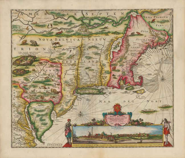
Subject: Colonial New England and Mid Atlantic

Period: 1690 (circa)

Publication:

Color: Hand Color

Size:
21.3 x 18 inches
54.1 x 45.7 cm
Download High Resolution Image
(or just click on image to launch the Zoom viewer)

This is one of the most decorative colonial maps of the United States and the last in the Jansson/Visscher series. Geographically and stylishly the map is derived from Visscher's map of circa 1655. It covers the region from Chesapeake Bay to Penobscot Bay and includes the placement of nearly every colonial settlement along the coastline and rivers. The land is fully engraved to show forests, mountains, rivers and lakes with most of the geography based on the work of Champlain. This is the third state, revised to show Niew Castel alias Sandhoeck on the west side of the Delaware Bay, and Yermonton above Philadelphia. The Delaware River was completely redrawn to erase a connection with the Hudson River. An array of domestic animals have been added to the wild animals and Indian village scene. The most important feature of the map is the superb view of New York below the title cartouche that was taken from the Visscher map. In this state the title to this view acknowledges the English hold over the city with Nieuw Yorck, eertys Genaemt above the original title Nieuw Amsterdam op't Eylant Manhattans.

References: Burden #434; McCorkle #680.2; Tooley (Amer), p. 286, Campbell, Jansson-Visscher #9a.

Condition: B+

There is some minor soil and creasing along the centerfold. The map has been completely remargined seamlessly using the leaf-casting method and period paper, with some loss of image at top replaced in very skillful facsimile. Some minor paper weaknesses have also been strengthened on verso with light Japanese tissue backing.

Estimate: $4,000 - $5,000

Sold for: $3,000

Closed on 2/16/2011

Archived