Catalog Archive
Auction 135, Lot 170

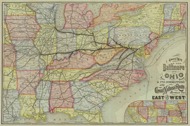
"General Map of the Baltimore and Ohio Rail Road & its Connections The Great National Route Between the East and West", Railroad Companies, (Various)

Subject: Eastern United States

Period: 1877 (dated)

Publication:

Color: Printed Color

Size:
20.3 x 13.3 inches
51.6 x 33.8 cm
Download High Resolution Image
(or just click on image to launch the Zoom viewer)

This is an early map and timetable of the B&O Railroad and its connections. On one side is the beautifully colored and printed map with the title given above. The B&O routes are shown via bold black lines with other lines shown by smaller lines. All stations are located and named. The map extends to the edge of Texas, Kansas, etc., with an inset map extending to California. Fancy period titling, crisp engraving and fine color make this a handsome railroad map. The verso has a timetable and promotional panels of the B&O including sections on Summer Resorts, general information for passengers plus a specific guide for European Travelers, a Condensed Time Table from Chicago, and more. Self folds into printed covers with the B&O logo front and back. An early and beautifully printed railroad map by the Rand McNally company.

References: Modelski #53.

Condition: A+

Beautiful color, very crisp impression. Folding as issued.

Estimate: $160 - $200

Sold for: $120

Closed on 2/16/2011

Archived