Catalog Archive
Auction 135, Lot 151

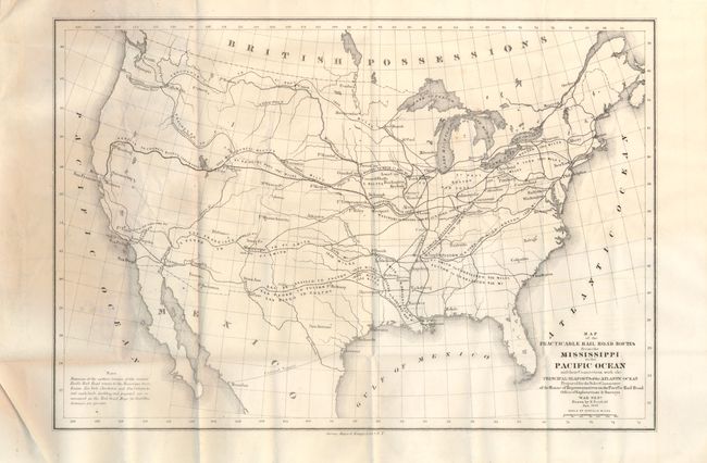
"Map of the Practicable Rail Road Routes from the Mississippi to the Pacific Ocean and their Connection with the Principal Seaports of the Atlantic Ocean… [with] Report", U.S. War Department

Subject: United States

Period: 1859 (dated)

Publication: H.R. Doc No.428, 36th Congress, 1st Session

Color: Black & White

Size:
14 x 9.5 inches
35.6 x 24.1 cm
Download High Resolution Image
(or just click on image to launch the Zoom viewer)

The title for this map's continues "Prepared for the Select Committee of the House of Representatives on the Pacific Rail Road…Drawn by E. Freyhold Jan. 1859." The map folds into the original report "Pacific Railroad. To accompany Bill H.R. No. 646 . Mr. Curtis from the select committee on the Pacific Railroad, made the following Report." The report is in original self-wrappers, 28 pp, uncut and untrimmed, never bound. The map is described in the text as a miniature of the large Humphreys/Warren map, but it is quite different. In includes the entire United States with the connections and distances of the possible routes to the major east coast cities. The majority report called for the selection of the central route, a variation of which became the first trans-continental railroad. This map apparently was not issued in the serial set and is not referenced in Wheat. We find no previous sales of what appears to be an important and scarce Freyhold map and report used in discussions and decision-making regarding the construction of the trans-continental railroad. Arguing for an overland route, the report lists recent steamboat losses to underscore the advantages of the rail system. Listed are 35 steamboats lost in the last five year including 2307 people. The largest single incident listed involved the Steamer Central America who lost 387 crew and passengers and over $2,500,000 in cargo including a treasure trove of freshly minted gold coins from the Carson City mint. After 131 years the ship was located in the Caribbean in 1987 in waters over 8000 feet deep. The complex recovery effort included a few members with deep water recovery experience gained on the earlier Hughes Glomar Explorer. The Explorer recovered most of a Soviet nuclear submarine at over 16,000 feet. This lot contains the rare and unopened report and accompanying folding map.

References:

Condition: A

The map is on fine banknote quality paper. No flaws but on verso is a penciled list of names in a table.

Estimate: $200 - $400

Sold for: $100

Closed on 2/16/2011

Archived