Catalog Archive
Auction 134, Lot 75

"Americae nova Tabula", Blaeu, Willem

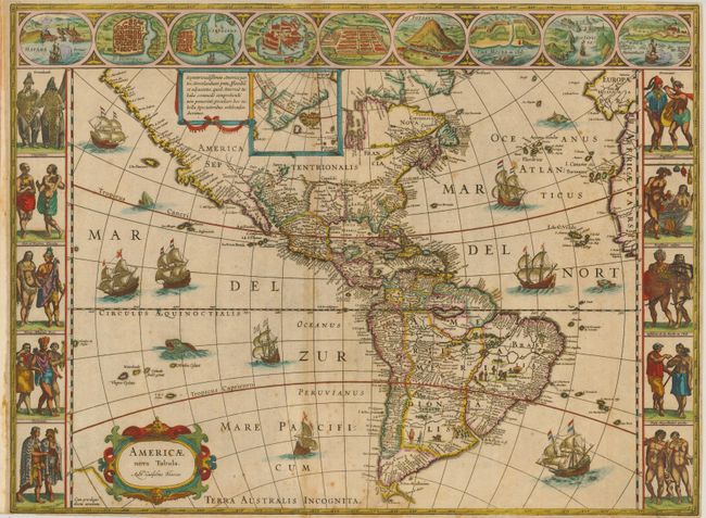
Subject: Western Hemisphere

Period: 1621 (circa)

Publication:

Color: Hand Color

Size:
22 x 16.3 inches
55.9 x 41.4 cm
Download High Resolution Image
(or just click on image to launch the Zoom viewer)

This stunning carte-a-figures map is a superb example of the fine art of decorative cartography and a seventeenth-century European view of the New World. The coastal outlines generally follow Ortelius and Wytfliet with nomenclature from a variety of explorers and colonists. Panels at sides, each with five portraits of the native inhabitants were taken from John White (Virginia), Hans Staden (Brazil) and other early explorer's accounts. Across the top are nine town plans including Havana, St. Domingo, Cartegena, Mexico City, Cusco, Potosi, I. la Mocha in Chile, Rio de Janeiro and Olinda in Brazil. This is one of the few maps of the Americas by this famous Dutch cartographer. The map itself is similar to Blaeu's wall map of 1608 with the additional discoveries of Henry Hudson in North America, and Tierra del Fuego with Le Maire Strait. This is the third state of the plate with the imprint changed to Auct: Guiljelmo Blaeuw and a blank verso.

References: Burden #189; Goss (Blaeu) p. 156; Tooley (Amer) p. 297.

Condition: B

Good impression with attractive old color. Issued folded for inclusion in a small folio format atlas. Narrow margins, varying from 1/16" to 1/4" with paper added to the margin at right. There is some minor foxing and a couple extraneous creases at center. There is an old repaired tear and small hole just below Tierra del Fuego.

Estimate: $5,000 - $6,000

Sold for: $4,500

Closed on 12/1/2010

Archived