Catalog Archive
Auction 134, Lot 705

"Maris Pacifici, (quod vulgo Mar del Zur)", Ortelius, Abraham

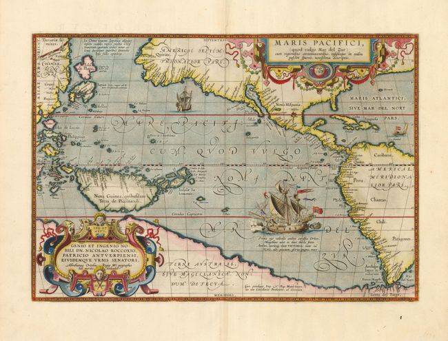
Subject: Pacific Ocean

Period: 1589 (dated)

Publication: Theatrum Orbis Terrarum

Color: Hand Color

Size:
19.8 x 13.6 inches
50.3 x 34.5 cm
Download High Resolution Image
(or just click on image to launch the Zoom viewer)

Ortelius’ seminal map of the Pacific is the first printed map devoted to the Pacific and the first to label the Americas separately as North and South subsequent to Mercator’s 1538 World Map. The map draws on the cartography of Frans Hogenberg, Mercator’s world map of 1569, and Portuguese manuscript maps of Bartolomeo de Lasso. It widens the gap between Asia and North America while properly locating the Philippines and Japan, although there is an odd Isla de Plata above Japan. North America is depicted considerably narrower and more correctly at the Tropic of Cancer, and the head of the Gulf of California is shown in a new form with the R. Grande being introduced for the first time, although misplaced. The large southern continent, Terra Australis, stretches over the bottom of the map, but the name Tierra del Fuego appears south of the Strait of Magellan. The map is adorned with two elaborate cartouches and Magellan’s surviving ship Victoria is pictured along with two smaller ships. First state with the date 1589 in the cartouche. French text on verso, indicating a published date of 1598.

References: Burden #74; Cohen (West) pp. 31-33; Goss (NA) #14; Wheat (TMW) #24; van den Broecke #12.

Condition: A+

A fine example with a tiny professional repair on the centerfold.

Estimate: $9,000 - $11,000

Sold for: $8,000

Closed on 12/1/2010

Archived