Catalog Archive
Auction 134, Lot 620

"L'Asie, Selon les Nouvelles Observations…", Aa, Pieter van der
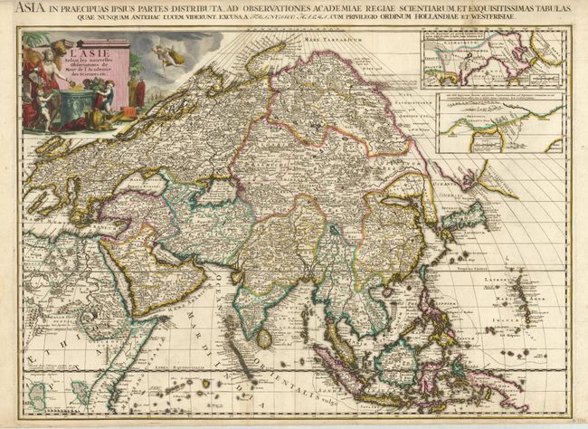
Subject: Asia

Period: 1713 (circa)

Publication: Le Nouveau Theatre de Monde

Color: Hand Color

Size:
26.3 x 18.5 inches
66.8 x 47 cm
Download High Resolution Image
(or just click on image to launch the Zoom viewer)

The main focus of this important and scarce map of Asia is the delineation of the northeast part of the continent from Jesuit sources. The northeast coast is severely truncated with the discoveries of Nicolas Witsen shown, and the partial coastlines of Jesso and Compagnies Land are depicted to the north of Japan. Inset in the North Pacific is a map of that same region based on the information from Father Martino Martini. It shows Jesso connected to the mainland with a narrow strait between it and a huge Compagnies Land. An inset below, taken from Father Ferdinand Verbiest, illustrates the road between Peking and Kirin and Nincrita. Father Verbiest's world map of 1674, which he compiled for the Chinese, subsequently led to the Jesuits obtaining a commission to make a comprehensive topographical survey for the empire. Although this was not completed until 1717, evidence that some of this new information was reaching Europe before that date is found on this map. The large title cartouche shows the female representation of Asia surrounded by a wealth of trade goods with a caravan in the background. A Latin title is in the top margin: "Asia in Praecipuas Ipsius Partes Distributa…"

References: Yeo #108.

Condition: B+

Dark impression with original color. There is some minor toning and a short fold separations on the two folds, one of which has a 1/2" tear just entering the map at bottom.

Estimate: $1,200 - $1,400

Sold for: $900

Closed on 12/1/2010

Archived