Catalog Archive
Auction 134, Lot 380

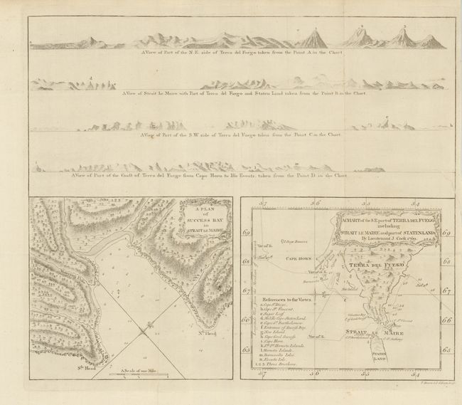
"A Chart of the S.E. part of Terra del Fuego including Strait le Maire and part of Staten-Land by Lieutenant J. Cook 1769 [on sheet with] A Plan of Success Bay in Strait le Maire", Cook, James (Capt.)

Subject: Argentina and Tierra del Fuego

Period: 1780 (circa)

Publication:

Color: Black & White

Size:
14.3 x 12.2 inches
36.3 x 31 cm
Download High Resolution Image
(or just click on image to launch the Zoom viewer)

This sheet contains two charts in the lower half beneath four coastal perspectives. The Terra del Fuego chart shows the tract of the Endeavor as Capt. Cook traveled from east to west between January 11th - 27th, 1769. Reference locates and names 14 places on the top view. The plan of Success Bay shows great detail including soundings, anchorage, a compass rose and includes a surprising amount of inland detail. Both charts have their own border and decorative rococo-style title cartouche. The four view perspectives show ship views of Terra del Fuego and Cape Horn from various angles This early Cook exploration map is from his first voyage. Published by Alexander Hogg and engraved by Bowen & Gibson, London.

References:

Condition: A

Beautiful, flawless chart that is clean and bright save for a short binding trim tear entering map about 1" in blank area above charts. Folding as issued.

Estimate: $120 - $160

Sold for: $120

Closed on 12/1/2010

Archived