Catalog Archive
Auction 134, Lot 349

"L'Amerique Meridionale Divisee en ses Principales Parties", Elwe, Jan Barend

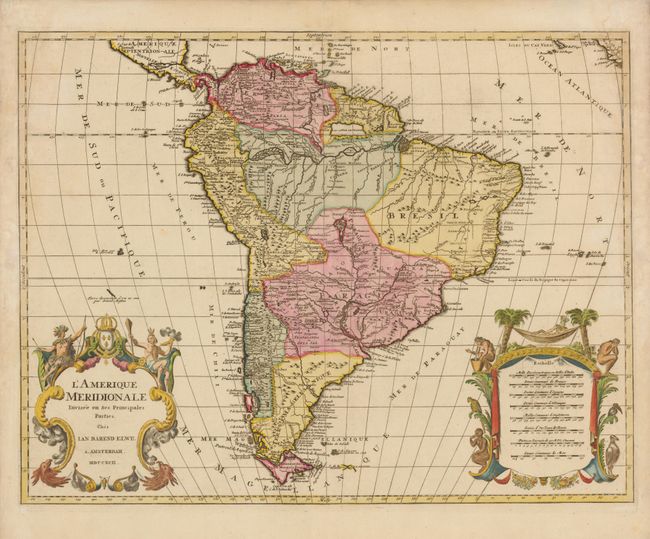
Subject: South America

Period: 1792 (dated)

Publication: Atlas Geographique et Universel…

Color: Hand Color

Size:
23.7 x 18.2 inches
60.2 x 46.2 cm
Download High Resolution Image
(or just click on image to launch the Zoom viewer)

This handsome map of the continent is decorated with elaborate title and scale of miles cartouches balancing the lower portion of the map. The continent is divided into the French, Spanish, Portuguese and Dutch possessions. The fourteen coastal Capitaineries created by the Portuguese are delineated in Brazil. The fictitious Mer de Parime is named along with the mythical Manoa el Dorado on its banks. The course of the Amazon is delineated in a fairly accurate manner, yet it shows the river's source in a fascinating, interlacing maze of waterways. The Rio Paraguay erroneously begins in a lake named Xarayes in the middle of Brazil. The map is copied from Jaillot's map of the same title, but is slightly smaller and the two elaborate cartouches are identical with images of Native Americans, flora and fauna. One cartouche encloses the map's title while the other presents eight different distance scales, recording the diversity of European measurement systems before the adoption of the metric system during the French Revolution.

References:

Condition: A

Fine impression and original color with some minor toning and damp stains in the blank margins that barely intrude into the upper corners of the map.

Estimate: $475 - $600

Sold for: $350

Closed on 12/1/2010

Archived