Catalog Archive
Auction 134, Lot 234

"[View of Capital Building and Washington] Topographical Map of Virginia between Washington and Manassas Junction / Military Map of Maryland & Virginia", Magnus, Charles

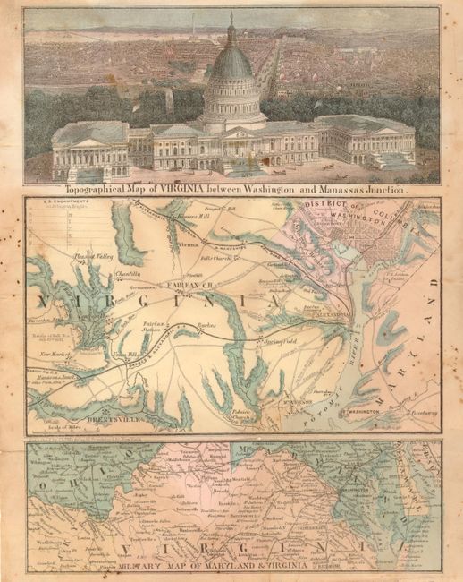
Subject: District of Columbia

Period: 1863 (circa)

Publication:

Color: Hand Color

Size:
10 x 7.5 inches
25.4 x 19.1 cm
Download High Resolution Image
(or just click on image to launch the Zoom viewer)

This uncommon letter sheet map was published by Charles Magnus sometime after September of 1861, the last date of an event to be found on the map. The top panel is a detailed bird's-eye view of the Capital Building with the city in the background. A preliminary plan of the Washington monument can be seen in the far background. This view shows the building completed with the statue of freedom on top which did not occur until 1863. The middle panel is a detailed map of north-east Virginia and Washington. It shows roads, railroads, towns and cities naming Bristoe, Fairfax, Pleasant Valley, Mt. Vernon, Fort Washington, Hunter's Mill, Prospect Hill and Washington D.C. at upper left. At the right of the map is Battle of Bull Run with North and 'Rebel' positions noted. The map in the bottom panel covers the majority of Virginia and Maryland with portions of New Jersey, Delaware, Ohio and Kentucky. At the upper left corner is an embossed logo with two lions that appears to say "Hammermill Suppliers." Charles Magnus produced several maps and views during the Civil War and this small work has drawn on his prior work.

References:

Condition: B

Issued folding, now flattened. Nice impression and coloring but with some fly specks, mostly in margins, and a little scattered toning. One pinhole at a fold intersection and archival tape on a fold on verso.

Estimate: $140 - $180

Sold for: $160

Closed on 12/1/2010

Archived