Catalog Archive
Auction 133, Lot 61

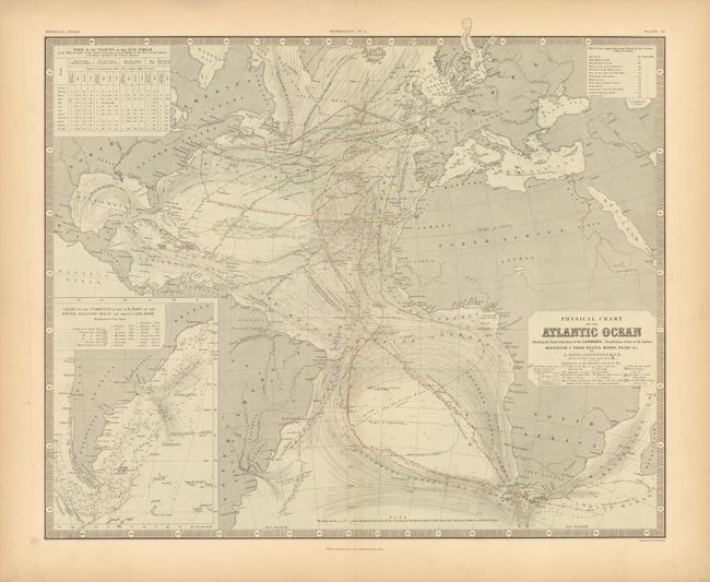
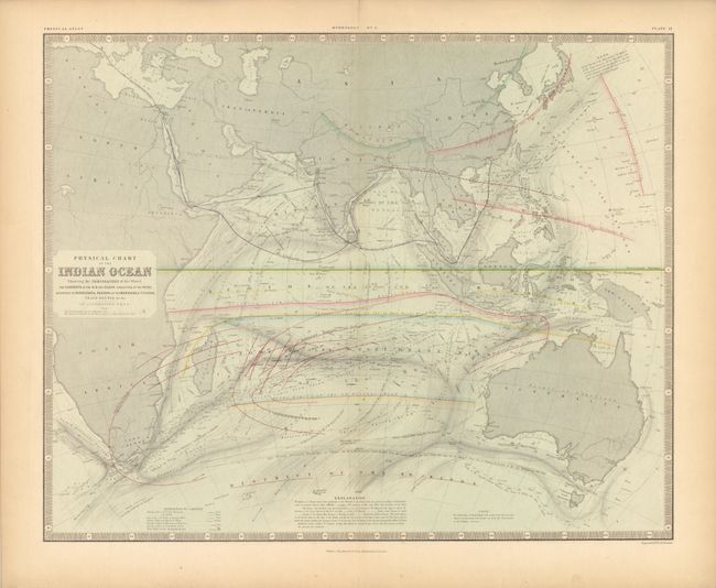
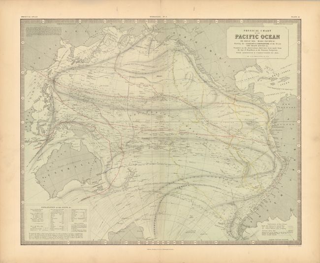
"[Lot of 3 - Ocean Currents]", Johnston, Alexander K.

Subject: Cartographic Miscellany

Period: 1856 (published)

Publication: Physical Atlas of Natural Phenomena

Color: Printed Color

Size:
23.3 x 18.7 inches
59.2 x 47.5 cm
Download High Resolution Image
(or just click on image to launch the Zoom viewer)

These three thematic maps are finely engraved and filled with an immense amount of information on ocean currents, wind directions, regions of hurricanes and typhoons, surface temperatures, etc. Each is a double folio sheet surrounded by a keyboard-style border. Each with the approximate dimensions given.

1) Physical Chart of the Atlantic Ocean Showing the Form & direction of the Currents; Distribution of heat at the Surface, Navigation & Trade Routes, Banks, Rocks & c.. Table gives the "Velocity of the Gulf Stream" for each month at three locations. Large inset, "Chart of the Currents in the S.W. Part of the South Atlantic Ocean and around Cape Horn" is drawn on the same scale. Two extensive legends: one for physical details and the other describes the various routes of 18 explorers.

2) Physical Chart of the Indian Ocean Showing the Temperature of the Water, the Currents of the Air and Ocean, Directions of the Wind, Districts of Hurricanes, Regions of the Monsoons & Ty-Foons, Trade Routes &c. &c.. This map features the various weather phenomena with green, yellow, blue, red and orange traces to delineate the regions of Monsoons, Hurricanes, extreme storms, Typhoons, etc.

3) Physical Chart of the Pacific Ocean or Great Sea (Mare Pacifico). Showing the Currents & Temperature of the Ocean the Trade Routes &c.. This highly detailed chart describes the currents of the Pacific including the Antarctic Drift, South Pacific, Mentor's Counter Drift, Equatorial Current, the Origin of the Peruvian Coast Current of Cold Water, Russell's Drift, Carolinian Monsoon Current, North Pacific Drift and more. The Probable limit of Drift Ice is shown laying between about 55° and 65° South Latitude. The chart also includes the routes of many explorers as explained in the legend.

References:

Condition: A

Beautiful engraving and color on thick paper with wide, original margins. The images are fine, flawless, but the thick paper has short splits top and bottom in blank margins. Some marginal edge toning.

Estimate: $200 - $300

Sold for: $150

Closed on 9/1/2010

Archived