Catalog Archive
Auction 133, Lot 404

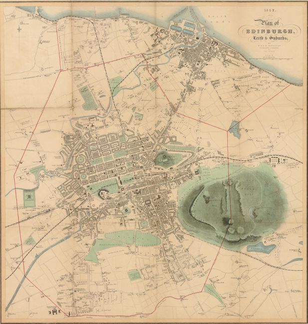
"Plan of Edinburgh, Leith & Suburbs", Johnston, W. & A.K.

Subject: Edinburgh, Scotland

Period: 1857 (dated)

Publication:

Color: Hand Color

Size:
19 x 19.8 inches
48.3 x 50.3 cm
Download High Resolution Image
(or just click on image to launch the Zoom viewer)

This scarce pocket map details the city with delicate hand coloring to the parks, meadows, rivers and lakes. The map extends to include the harbor with breakwaters and the Victoria Dry Docks, to Cairntwos in the southeast and to Granton in the northwest. Numerous toll booths are shown along certain roads. Locates the Piershill Barracks, cemeteries, commercial buildings including numerous brick and tile works, hospitals, etc. Delineates the railways including the Edinburgh & Glasgow railway, the North British Railway and the Edinburgh, Leith and Granton railway. Blank verso. Attached to original pictorial paper covers (5" x 7.3") with fancy scroll work, a coat of arms on the cover and decorative flourishes at each corner. The back cover lists for sale "The Counties of Scotland, with Memoir of Scottish Geography, Index, etc.," and other maps including the case map "Knox's Environs of the City of Edinburgh," 31" c 22".

References:

Condition: B+

Toned at edges of fold aligned with edge of back cover and some small loss at this area. Experetly backed along most folds on verso with tissue. Front cover is a little soiled near edges and an owner's name in ink is at top.

Estimate: $250 - $350

Sold for: $190

Closed on 9/1/2010

Archived