Catalog Archive
Auction 133, Lot 290

"Map Showing the Location of Sheridan, Wyoming, and Surrounding Reservations…", U.S. Government
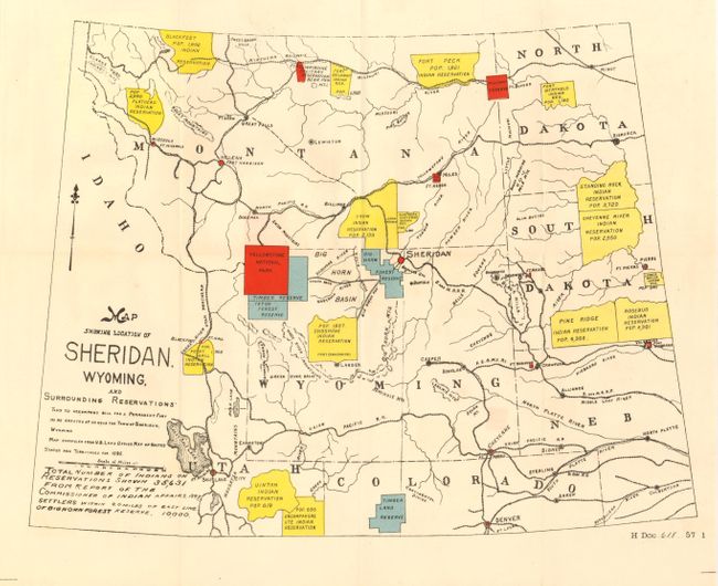
Subject: Wyoming

Period: 1898 (published)

Publication: HR Doc. 618, 57th Cong. 1st Sess.

Color: Printed Color

Size:
17 x 12.5 inches
43.2 x 31.8 cm
Download High Resolution Image
(or just click on image to launch the Zoom viewer)

The title continues "This to accompany bill for a permanent fort to be erected at or near the Town of Sheridan, Wyoming," leading to the building of Fort McKenzie. This colorful map was "compiled from U.S. Land Office Map of United States and Territories for 1895." The map is centered on Sheridan and shows a large portion of the West to include all of Wyoming and Montana and parts of north and south Dakota, Nebraska, Colorado and Utah. Shows all Indian Reservations within this large area in yellow, plus the Forest Reserves and Military Reserves, and Yellowstone National Park. Shows only the larger towns but delineates all of the region's railroads and names all forts. Population given for each Indian Reservation within their extent. A note at lower left states the "Total Number of Indians on Reservations" is 35,631 and gives the number of "Settlers within 20 miles of East Line of Big Horn Forest Reserve" at 10,000. This map was issued in three states, this being the second with the addition of Indian populations.

References: Blevins #551.

Condition: A+

Flawless example.

Estimate: $100 - $120

Unsold

Closed on 9/1/2010

Archived