Catalog Archive
Auction 133, Lot 279

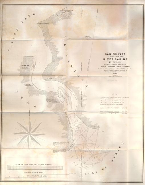
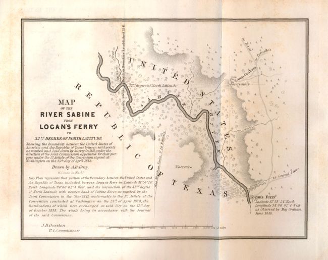
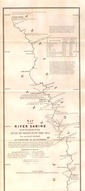
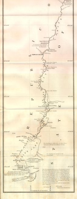
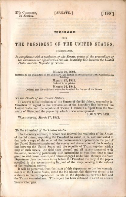
"Message from the President…Communicating…Proceedings of the Commissioner Appointed to Run the Boundary Line Between the United States and the Republic of Texas", U.S. Government

Subject: Texas

Period: 1842 (published)

Publication: Sen. Doc. No. 199, 27th Cong., 2d Sess.

Color: Black & White

Size:
6 x 9 inches
15.2 x 22.9 cm
Download High Resolution Image
(or just click on image to launch the Zoom viewer)

This is the highly desirable report on the boundary survey between the Republic of Texas and the United States. Streeter calls this publication of "prime importance" and the maps "the most important in Texas history, in that they show the final boundary between Texas and the U.S. from the Gulf of Mexico to the Red River." The act admitting Louisiana to statehood in 1812 contained a clause defining its original boundaries. When Texas declared its independence in 1835, these borders came into question. This survey was made shortly thereafter and appears to have been the basis for a more detailed survey in 1840 to determine the eastern boundary of Texas. Disbound, 74 pp. plus the five page "Message from the President…". Complete report including the original six maps:

1) "Sabine Pass and Mouth of the River Sabine in the Sea…" (17.5 x 22"). This map is among the most important government maps published during the period of Texas independence. It is was the first to depict the eastern border of Texas. It covers the section from Sabine Lake to the Gulf of Mexico and shows soundings, Sabine City and the U.S. Customs House. The map was surveyed under the direction of Major J.D. Graham U.S. Topographical Engineers by Lt. T.J. Lee of the U.S. Topographical Engineers and Capt. P.J. Pillans of the Texan Army, and drawn by Lt. Lee. Engraved by W.J. Stone. With scattered foxing. (B)

2) "Map of the River Sabine from Logan's Ferry to 32nd Degree of North Latitude" (8.5 x 6.5"). The map follows the boundary starting from a point on the river about 1/2 mile above Garrison Creek and down the river to Logan's Ferry (where the boundary ceases to follow the river). It is minutely detailed and filled with fascinating notations. Drawn by A.B. Gray, engraved by W.J. Stone and signed by J.H. Overton, U.S. Commissioner. (B+)

3) "Map of the River Sabine from its Mouth on the Gulf of Mexico in the Sea to Logan's Ferry in Latitude 31° 58' 24" North…" (7 x 34"). This map depicts the boundary starting from a mound erected at the mouth of the river and follows up the river to Logan's Ferry (where the boundary ceases to follow the river). The map is minutely detailed and filled with fascinating notations. Drawn by Lieut. T.J. Lee, U.S. Topographical Engineers, engraved by W.J. Stone and published in 1842. A small area of light offsetting. (B+)

Plus three detailed maps of the boundary in strip-chart style, each with the common title a "Part of the Boundary Between the United States and Texas." 4) From Sabine River, Northward, to the 36th Mile Mound" 5) North of Sabine River from the 36th to the 72nd Mile Mound" and 6) North of Sabine River, from the 72nd Mile Mound to Red River." Each with occasional light scattered foxing. (B+)

References:

Condition:

See individual descriptions.

Estimate: $600 - $800

Sold for: $1,900

Closed on 9/1/2010

Archived