Catalog Archive
Auction 133, Lot 277

"A Map of the Alleghany Monongahela and Yohiogany Rivers", Wightman, Thomas

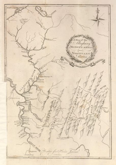
Subject: Pennsylvania

Period: 1805 (published)

Publication: Journal of a Tour in the Territory Northwest of the Allegheny Mountains…

Color: Black & White

Size:
9 x 13 inches
22.9 x 33 cm
Download High Resolution Image
(or just click on image to launch the Zoom viewer)

This is the first time we've encountered this rarity. It was engraved by Thomas Wighman for Thaddeus Mason Harris' journal "Made in the Spring of the Year 1803." With a compass rose and fleur-de-lys at upper right but no scale. It shows Pittsburgh at left center and extends to Chatauque Lake in New York and Lake Erie in the north, south to Clarksburg and east to Strasburg on the Condigwinnet River. Names Fort Cumberland, Bedford, Grahams, Berlin, Somerset, Union, and Connelsville. Towns located along the valley of the Allegheny River include New Geneva, Morgantown, Greensburg, Bridgeport, Fredericktown, Canonsburg, Elizabethtown, Franklin and more. Also names Braddocksfield, Fort Fayette, Potter's Cabin, Burnt cabins near Fannetsburg. Dotted lines delineate the numerous trails in the region. The mountains and terrain are depicted with a series of shaded three-dimensional hills. Each range is named. The title is in a wealth-style cartouche with ribbon below containing the Latin phrase "Flumina Amen Sylvasque Inglorius" (trans: May I love the rivers and forests without fanfare). This rare issue was published in Boston.

References: Phillips (M) pp. 99 & 680.

Condition: B+

Very nice example with good impression and full margins except on binding trim, as issued. Originally folded it is now flat and professionally backed with Japanese mulberry tissue. A couple light foxing spots.

Estimate: $250 - $300

Sold for: $210

Closed on 9/1/2010

Archived