Catalog Archive
Auction 133, Lot 18

"Nova Totius Terrarum Orbis Tabula", Danckerts, Justus
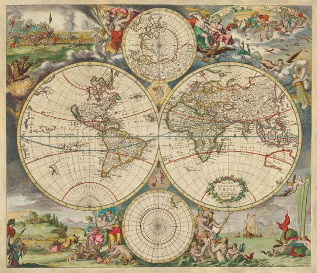
Subject: World

Period: 1680 (circa)

Publication:

Color: Hand Color

Size:
21.6 x 18.6 inches
54.9 x 47.2 cm
Download High Resolution Image
(or just click on image to launch the Zoom viewer)

This is Danckerts' version of De Wit's splendid maritime world map. The cartographic features include the island of California and open-ended Great Lakes on the Sanson model in North America. A remnant of Lake Parima is still shown in South America. In Africa, the Nile still rises from twin lakes and the interior is mostly guesswork. In Asia, Australia is represented only by the northern and western coastlines and Van Diemen's discoveries are shown in Tasmania and New Zealand. Above and below the map are polar projections, with only the tip of South America shown in the Antarctic sphere. Lively allegorical scenes representing the four elements surround the map. Fire is depicted by a fierce battle scene and the abduction of Persephone; air as the heavenly realm ruled by Zeus and Hera; water by Neptune with his entourage, sailing ships and a fantastic spouting whale; and earth by Demeter and two other earth goddesses in a peaceful scene of harvesting and husbandry. This is Danckerts' first of two similar maps, with geography identical to De Wit's original.

References: Shirley #495.

Condition: B+

There is professional restoration in the blank margins with a skillfully repaired tear in the polar sphere at bottom and a couple short marginal tears. There is some minor soil in the map.

Estimate: $5,500 - $6,500

Sold for: $4,250

Closed on 9/1/2010

Archived