Catalog Archive
Auction 133, Lot 146
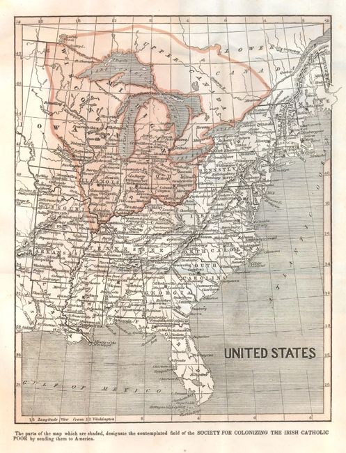
"United States",

Subject: Eastern United States

Period: 1842 (published)

Publication:

Color: Printed Color

Size:
8.3 x 10.5 inches
21.1 x 26.7 cm
Download High Resolution Image
(or just click on image to launch the Zoom viewer)

This is an early printed color map of the Untied States, most likely printed by Morris & Breese. The map shows all of the United States to the Mississippi River and north to include Upper Canada. The entire north central portion including Canada is shaded to indicate the area contemplated for colonization of "the Irish Catholic Poor by sending them to America." This fascinating map is bound as the frontis to the original November 1842 issue of the Home Missionary, and Pastor's Journal. The report is titled Grand Scheme fro planting Irish Catholic Colonies in the Western States (pp 145..168) which expands on the map. Sections of the report include "The Necessity for colonizing the surplus population" and the "Probabilities of Success." Helpfully the report states "the scheme would prove abortive" if clergy were not funded to accompany the masses. A rare issue in original green wrappers with title and contents.

References:

Condition: B+

Map and report pages are bright but with occasional light foxing. Cover with old owner's name in ink on front above border.

Estimate: $100 - $140

Sold for: $95

Closed on 9/1/2010

Archived