Catalog Archive
Auction 133, Lot 126

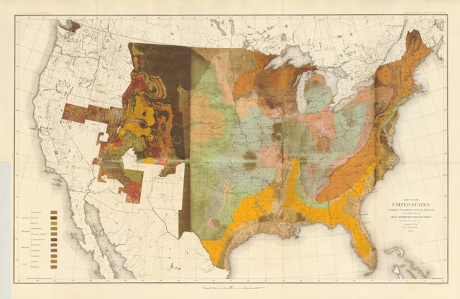
"Map of the United States Exhibiting the Present Status of Knowledge Relating to the Areal Distribution of Geologic Groups", U.S. Geological Survey (USGS)

Subject: United States

Period: 1884 (dated)

Publication: Fifth Annual Report of the United States Geological Survey…

Color: Hand Color

Size:
28 x 17.3 inches
71.1 x 43.9 cm
Download High Resolution Image
(or just click on image to launch the Zoom viewer)

This is the first published geological map of the United States by the nascent USGS. It is generally referred to as the McGee map after the compiler. The legend at lower left names and color codes twelve different geological formations. There is also very fine detail of hydrology. Vast areas of the western U.S. remain blank, reflecting the infancy and inadequacy of western geological explorations at the time, and coincidentally emphasizing the need for more congressional funding. The mapping of the King, Hayden, Powell and Wheeler surveys are evident in the West, but little else. This was Plate II in the annual report. This was the most up-to-date map at the time, but was soon to be superseded by Hitchock's 1886 map that augmented the western states' geological detail.

References:

Condition: A

Folding as issued. This example has a most interesting inking pattern, likely an error by the lithographer. Some of the green areas have been over-inked in brown resulting in nearly opaque portions most notably in Montana and the eastern portion of Wyoming and Colorado. Click <a href="http://www.oldworldauctions.com/archives/detail/img_detail.asp?lotno=161&title=Map+of+the+United+States+Exhibiting+the+Present+Status+of+Knowledge+Relating+to+the+Areal+Distribution+of+Geologic+Groups&filename=129-161&usepage=False&strType=Antique-map-chart">here</a> to see a comparison map correctly inked.

Estimate: $200 - $250

Sold for: $325

Closed on 9/1/2010

Archived