Catalog Archive
Auction 132, Lot 138

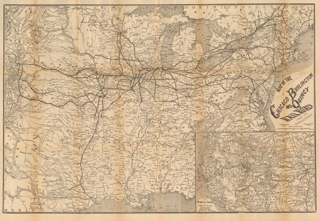
"Map of the Chicago Burlington and Quincy Railroad and its Connections", Rand McNally & Co.

Subject: United States - Railroad

Period: 1878 (dated)

Publication:

Color: Black & White

Size:
30 x 20 inches
76.2 x 50.8 cm
Download High Resolution Image
(or just click on image to launch the Zoom viewer)

This is an early folding map and timetable for the Chicago Burlington & Quincy Railroad system, dated in the winter of 1878. The large map shows the route and connecting lines centered on Chicago, extending to Bangor and Quebec and westward to Denver and south to Dallas, Houston, San Antonio and Galveston. Each railroad is named with hundreds of rail stations located and likewise named. At lower right is the large "Map of the Western States and Territories" which extends to Olympia, Portland, San Francisco, Los Angeles, and Fort Yuma.. It also provides great detail of the intra-state railroad system of California. This great piece of railroad ephemera has an extensive timetable on the verso of the map. The various panels also advertise Dining Cars by the Pullman Company, information for Emigrants plus two illustrated panels recommending "Elegant Dining Cars Which are run ONLY via the Burlington Route" and "Pullman's Drawing Room and Sleeping Coach." Self folds into 4" x 7.25" brochure with fancy logo for the railroad at top.

References:

Condition: B+

A little light fold toning and a couple very small fold intersection splits. Other wise a very nice example with full margins and no significant flaws, remarkable for a timetable that was normally considered disposable.

Estimate: $150 - $200

Sold for: $110

Closed on 6/2/2010

Archived