Catalog Archive
Auction 132, Lot 118

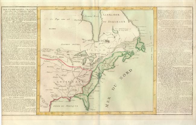
"[Des Possessions Francoises Aujourd'hui sous la Domination Angloises ...]", Clouet, Jean Baptiste Louis

Subject: Colonial United States and Canada

Period: 1767 (circa)

Publication: Geographie Moderne

Color: Hand Color

Size:
13.7 x 12.3 inches
34.8 x 31.2 cm
Download High Resolution Image
(or just click on image to launch the Zoom viewer)

This simple, yet interesting, map illustrates the French and British possession in the eastern part of North America. The British colonies stretch from Florida to Newfoundland and are confined east of the Appalachian and Allegany mountains. Louisiana takes in the entire region west of the mountains. The most interesting feature of the map is a system of lakes and rivers stretching from Lake Superior toward the Pacific - forming the elusive Northwest Passage. The map is flanked by columns of French text that describe the colonial possessions, major settlements and indigenous people. Accompanied by the introduction sheet of the atlas

References:

Condition: B+

The left margin of the map is trimmed into the neatline of the text panel, as issued, else very good. The text leaf is stained.

Estimate: $300 - $375

Sold for: $220

Closed on 6/2/2010

Archived