Catalog Archive
Auction 130, Lot 741

"Asiae XII Tab", Ptolemy/Mercator
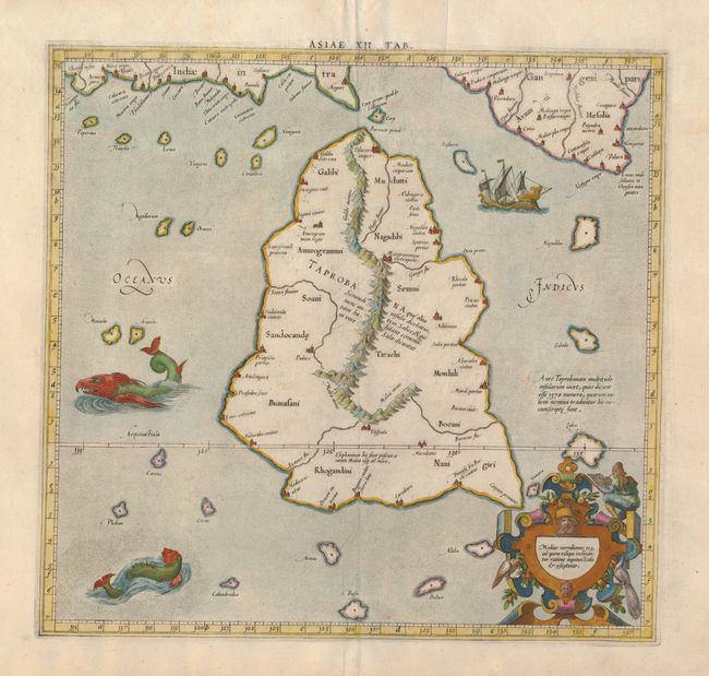
Subject: Sri Lanka

Period: 1605 (published)

Publication: Claudii Ptolemaei Alexandrini Geographiae…

Color: Hand Color

Size:
14 x 13.5 inches
35.6 x 34.3 cm
Download High Resolution Image
(or just click on image to launch the Zoom viewer)

For this map of Toprobana (Sri Lanka), Ptolemy drew on the accounts of travelers and sailors and though the information was secondhand and often inaccurate, it represented the most advanced account of the world's geography at that time. This map depicts the island with the typical misconceptions of the period with the enlarged island straddling the Equator and nearly divided by a ridge of mountains. A small part of India is incorrectly shown in the northeast corner of the map and a spurious coastline labeled Gangem fills the upper right corner. The stipple engraved sea contains an oriental ship and two great sea monsters. This edition is from the original plate without the decorative title cartouche. The cartouche at lower right identifies the location of the island and a mapmaker is perched on one of the elaborate straps.

References: Mickwitz & Miekkavaara (Nordenskiold) #229-28.

Condition: A

There are some minor repairs in the margins, well away from the map.

Estimate: $240 - $300

Sold for: $150

Closed on 12/2/2009

Archived