Catalog Archive
Auction 130, Lot 541

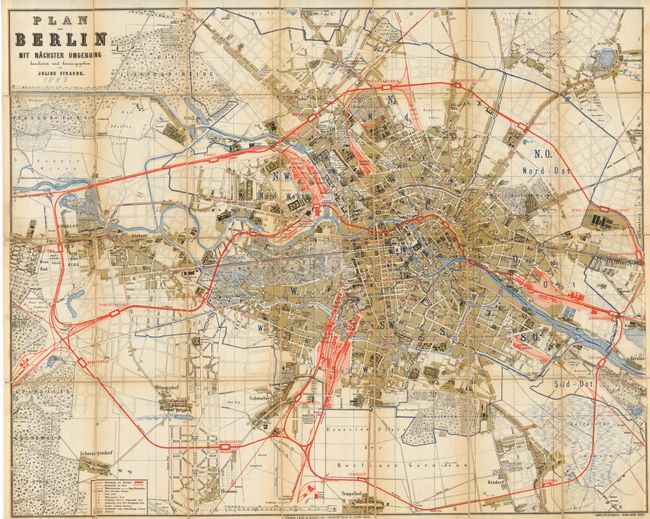
"Plan von Berlin mit Nachster Umgebung",

Subject: Berlin, Germany

Period: 1883 (circa)

Publication:

Color: Printed Color

Size:
31 x 24.5 inches
78.7 x 62.2 cm
Download High Resolution Image
(or just click on image to launch the Zoom viewer)

A very colorful segmented map by Julius Straube that shows Berlin in high detail with all streets and many prominent buildings named. Extends to include Rixdorf, Tempelhof, Wilmersdorf, Charlot, and Weissensee. Legend identifies 11 features including railroads, roads, post roads, telegraphs, etc. The 28 segments are mounted and fold to 4.5" x 6.75" with a green paper label. The map slips under a ribbon secured to the back cover, a most unusual arrangement that puts this issue half way between a pocket map and a case map. The cover is black cloth with gilt stamped title. The 24pp booklet inside is an alphabetical list of streets, parks, etc. The map is not dated but a pencil note "1883" below title appears contemporary and agrees with the maps geography, paper and style. An uncommon issue.

References:

Condition: B+

Bright color with just a little segment edge toning. One segment at right edge with a short split in linen. The cloth covers are fine but the spine is mostly cracked at back with a segment at bottom nearly loose.

Estimate: $180 - $200

Sold for: $130

Closed on 12/2/2009

Archived