Catalog Archive
Auction 130, Lot 407

"Totius Europae Littora Novissime Edita. Pascaert Vertoonende alle de See-Custen van Europa", Ottens, Reiner and Joshua
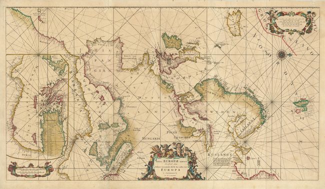
Subject: Europe

Period: 1745 (circa)

Publication: Atlas der Zeevaart

Color: Hand Color

Size:
35 x 19.5 inches
88.9 x 49.5 cm
Download High Resolution Image
(or just click on image to launch the Zoom viewer)

This fabulous portolan-style sea chart is oriented with west at the top. It covers the Atlantic coastlines from northwest Africa to Greenland, the Mediterranean, and the North Sea; thus covering from Iceland to Nova Zemla and from Spitzbergen to Morocco. Inset at left is continuation chart of the Eastern Mediterranean that covers the interior of northern Africa. This chart has a long and influential publishing history. The map originated in 1675 by Frederick de Wit who compiled it from Blaeu's four-sheet chart of Europe and the Atlantic. De Wit's plates came into the possession of Louis Renard (c. 1715) who revised the chart, removed some of the decorative elements, and extended it to include more of Greenland and the Azores. It then came into the hands of the Otten brothers who issued it without the extension. It is richly embellished with a beautiful compass rose, and three cartouches featuring a host of inquisitive putti.

References:

Condition: B+

Fine impression and original color. There is an old paper repair on a tear in the Mediterranean Sea, else very good.

Estimate: $4,000 - $4,750

Sold for: $4,000

Closed on 12/2/2009

Archived