Catalog Archive
Auction 130, Lot 296

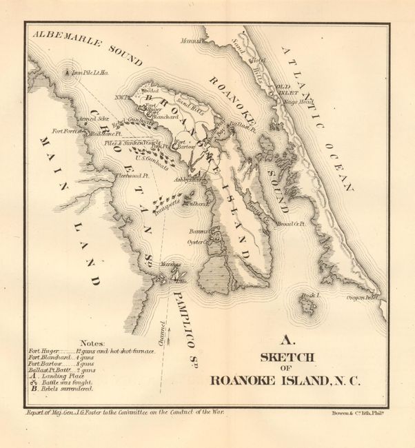
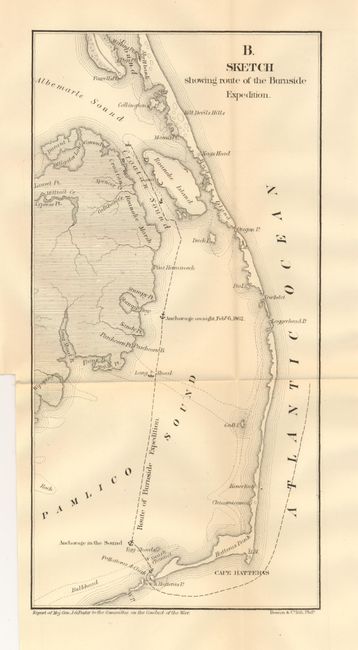
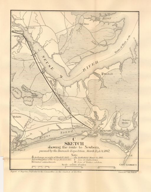
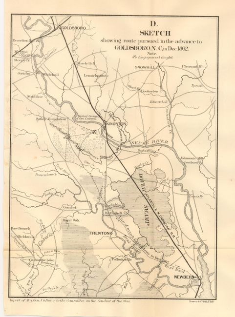
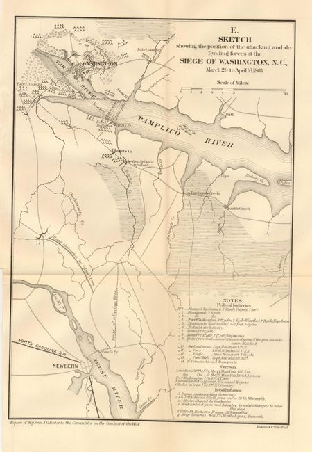
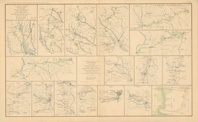
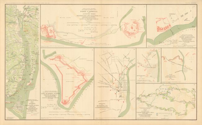
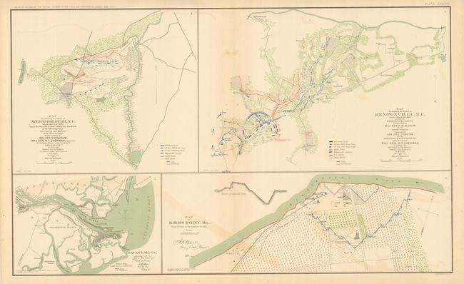
"[Lot of 8 - Civil War in North Carolina]",

Subject: North Carolina, Civil War

Period: 1866-92 (published)

Publication:

Color:

Size:
See Description
Download High Resolution Image
(or just click on image to launch the Zoom viewer)

Collection of Civil War maps related to the war in North Carolina. The first five were published in 1866 in Maj. Gen. J.G. Fosters Report to the Committee on the Conduct of the War, published by Bowen & Company, Philadelphia.

1) A. Sketch of Roanoke Island, N.C. (6.5 x 7"). Great detail of the island and the immediate area. Shows a line of eight U.S. Gunboats with Transport ships a little to the south. Above the gunboats is an area of Piles & Sunken Vessels with the Rebel Gunboats above. On the island is Fort Blanchard and Huger. The notes at lower left list the armaments at each fort: e.g. Fort Huger has 12 guns and a hot shot furnace. (A+)

2) B. Sketch Showing Route of the Burnside Expedition. (6 x 12.3"). Centered on Pamlico Sound the map locates Nags Head, the light at Loggerhead, Roanoke Islands, Cape Hatteras and more. The course and anchorages of Burnside is delineated with dotted lines. (A)

3) C. Sketch Showing the Route to Newbern, Pursued by the Burnside Expedition, March 13, & 14, 1862. (7 x 8.5"). Centered on the mouth of the Neuse River the map extends from Newbern to Beaufort. Locates Bay River, Hadnots, Smyrana Straits, Morehead City, Carolina City and the railroad between Newbern and Beaufort. Notes explain the anchorage, battlefield, obstructions, and the Line of Yankee catchers. (A)

4) D. Sketch Showing Route Pursued in the Advance to Goldsboro, N.C. in Dec. 1862. (7 x 9.5") Centered on Kingston the map locates Dover Swamp, Trenton, Newbern, and extends north to Goldboro. Delineates the railroad, Neuse River, Trent River and much more. (A+)

5) E. Sketch Showing the Position of the Attacking and Defending Forces at the Siege of Washington, N.C., March 29 to April 16, 1863. (8.3 x 11.8"). This great map extends from Newbern to the Capital. With many troop positions and camps located as well as the Rebel siege batteries north of Washington. Locates where Gen. Spingla was repulsed, and names South Creek, Durham's Creek, Hope, Bath, and more. Extensive notes further describe troop operations. (A)

6-7) Plate LXXXVI, CXXXII, CXXXIII from Atlas to Accompany the Official Records of the Union and Confederate Armies. (27 x 16.5"), printed color. A nice group of maps related to North Carolina and a few other states. The first (Plate LXXXVI) contains 17 Campaign Maps related to the 2nd Division, 20th Corps under Bvt. Maj. Gen. J.W. Geary and drawn by Capt. O.L.F. Brown of the Engineers. Includes Raleigh, Washington, D.C., Savannah, Richmond, Fayetteville, Chesterfield, and more. The next (Plate CXXXII) sheet has eight panels showing Champion's Hill, Miss; Augusta; Columbus, GA; Fort Johnston; Fort Caswell; and the Rebel Works on Smith's Island, plus a few more. The last (Plate CXXXIII) has four large panels including Bentonville, Bird's Point, Averaborough, and a nice map of Savannah and vicinity to the mouth of the Savannah River. All three are in very nice condition and much better than normally found. (A)

References:

Condition:

See individual descriptions.

Estimate: $120 - $160

Sold for: $220

Closed on 12/2/2009

Archived