Catalog Archive
Auction 130, Lot 274

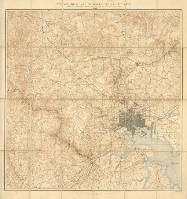
"Topographical Map of Baltimore and Vicinity", U.S. Geological Survey (USGS)

Subject: Baltimore, Maryland

Period: 1892 (dated)

Publication:

Color: Printed Color

Size:
23.5 x 24 inches
59.7 x 61 cm
Download High Resolution Image
(or just click on image to launch the Zoom viewer)

This topographical map is presented as a case map that was "Published by the John Hopkins University on the Topographic Base of the U.S. Geological Survey." The map is segmented and mounted on linen with the original case. The map provides fine detail on a scale of 1 mile per inch. Baltimore is shown with a heavy street grid with named roads and railroads radiating in all directions. The map extends to include Knoebel, Wellham Cross Roads, Simpsonville, and Finksburg with the larger towns of Towson and Lutherville also noted. Locates ferries, copper mines, contour to 20 feet, colleges, etc. The map folds and fits into the 4.5" x 7" brown cloth case. Printed by the A. Huen Company of Baltimore.

References:

Condition: A

The map is generally clean with just a hint of toning on a few linen/paper edges and some old pencil titles on the linen. Case is rubbed with the cloth frayed along the bottom edge.

Estimate: $140 - $180

Sold for: $100

Closed on 12/2/2009

Archived