Catalog Archive
Auction 130, Lot 225

"Geological Map of the Route explored by Lt. A.W. Whipple…From the Mississippi River to the Pacific Ocean 1853-1854", Whipple, Amiel Weekes

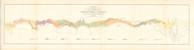
Subject: Southwestern United States

Period: 1859 (published)

Publication: U.S. Pacific Railroad Surveys

Color: Printed Color

Size:
36.7 x 8 inches
93.2 x 20.3 cm
Download High Resolution Image
(or just click on image to launch the Zoom viewer)

This very colorful map details the country from Memphis across the West to the small town of Los Angeles. The underlying geology surveyed by the notable geologist Jules Marcou is delineated and color-coded with a legend across the bottom naming nine formation. The Atchison, Topeka and Santa Fe Railroad later ran along the western part of this survey. A few cities are located along the way; Helena, Napoleon, Vicksburg, Pine Bluff, Little Rock, Fort Smith, San Antonio, Fort Defiance and Needles. The route cuts across the Llano Estacado, north of the Wichita Mountains, and along the edge of the Mogollon Rim, here named the Sierra Mogoyon.

References:

Condition: A

Folded as issued with a lazy crease along one fold. Some toning in upper margin at edge and one fold with a tiny amount of spotting. Bright color and full margins.

Estimate: $160 - $200

Sold for: $120

Closed on 12/2/2009

Archived