Catalog Archive
Auction 130, Lot 214

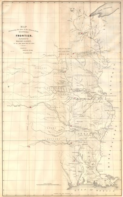
"Map Illustrating the plan of the defences of the Western Frontier, as proposed by Maj. Gen. Gaines, in his plan dated Feby. 28th 1838 [with HR report]", Burr, David H.

Subject: Central United States

Period: 1838 (dated)

Publication: HR Doc. No. 311, 25th Cong., 2d Sess

Color: Black & White

Size:
14.3 x 23.5 inches
36.3 x 59.7 cm
Download High Resolution Image
(or just click on image to launch the Zoom viewer)

This map was issued as part of the continuing debate over the nature of the Frontier Defenses between the Mississippi River and the Rocky Mountains. General Edmund P. Gaines, one of the most visionary military men of the 19th century, set out this proposal. His plan called for a system of military railroads that would permit the rapid movement of troops, not only between St. Louis and the frontier, but between Atlantic coastal forts and western frontier forts. In the 1830's this was a revolutionary idea, as railroads were in their infancy with only a few local lines connecting eastern cities. The map depicts the United States territory west of the Mississippi River, including lands making up present-day Louisiana, Arkansas, Missouri, the Indian nations bordering them to the west. Lands claimed and ceded by various Native American tribes, and lands assigned to tribes are indicated, as well as proposed forts and railroads. This map is part of a series, together with those illustrating the proposals of J.R. Poinsett and Charles Gratiot, which provide a fascinating comparison of the region, locating many military forts and outposts from Ft. Jessup to Ft. Snelling. The map is uncolored except for red marking the locations of the forts. This map is not from the later American State Papers, but indeed is offered with the original report "Defence of the Western Frontier. A Plan for the Defence of the Western Frontier, Furnished by Major General Gaines, February 28, 1838." This map is scarce, more so with the original report which gives the map a historical context.

References:

Condition: B+

The report has an occasional spot, the first few pages much more so. The map has a little toning on one vertical fold and a short binding trim tear.

Estimate: $250 - $300

Sold for: $1,400

Closed on 12/2/2009

Archived