Catalog Archive
Auction 129, Lot 74

"L'Amerique Septentrionale & Meridionale Divisee en ses Principales Parties…", Valck, Gerard

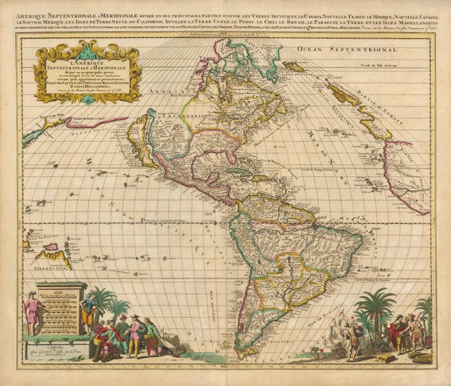
Subject: Western Hemisphere

Period: 1695 (circa)

Publication:

Color: Hand Color

Size:
22.8 x 19.3 inches
57.9 x 49 cm
Download High Resolution Image
(or just click on image to launch the Zoom viewer)

This beautiful map of the Americas is derived from Jaillot's map of North America in 1674, which in turn drew on the cartography of Nicolas Sanson. California appears as an island and the Great Lakes are open-ended in the west. The R. del Norte (Rio Grande) rises from a large lake in Apache country and flows incorrectly into the Mer Rouge between the mainland and the island of California. A spurious lake is depicted in the Appalachian Mountains just above Floride Francoise. In the North Pacific several coastlines stretch toward Asia with Japan appearing on the left border. In the South Pacific Terre de Quir and the Salomon Islands are depicted. The mythical Lac Parime appears in South America with the golden city of Manoa el Dorado on its shore. The bottom of the map is richly embellished with two great scenes of Europeans trading with natives. The scene on the left incorporates eight distance scales into a large monument. The title cartouche is rendered in the flourishing style that gained popularity at the turn of the seventeenth century. A second title is in the top margin.

References: Burden #713; McLaughlin #153.

Condition: B+

Good impression and original color with mild toning, a couple small spots, and an old paper repair on the lower centerfold.

Estimate: $1,900 - $2,200

Sold for: $1,300

Closed on 9/23/2009

Archived