Catalog Archive
Auction 129, Lot 333

"Map of Texas, compiled from Surveys recorded in the Land Office of Texas, and other Official Surveys", Arrowsmith, John
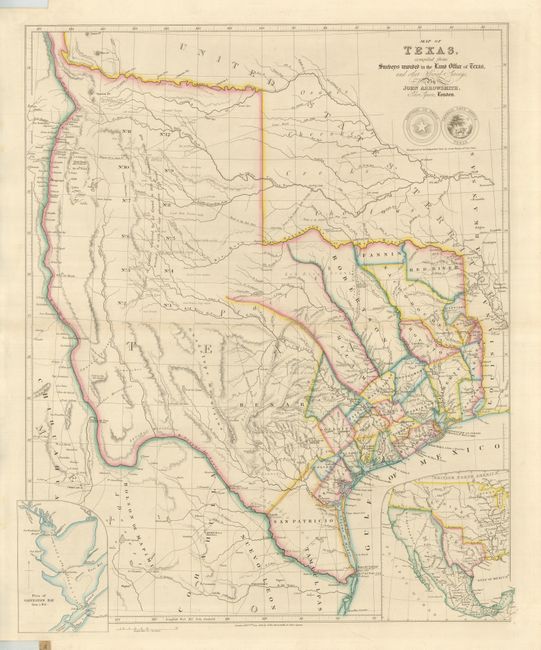
Subject: Texas

Period: 1843 (dated)

Publication: London Atlas

Color: Hand Color

Size:
19.8 x 24 inches
50.3 x 61 cm
Download High Resolution Image
(or just click on image to launch the Zoom viewer)

This is the third edition of this scarce and important map of the Republic of Texas. It is likely the first to show the full extent of Texas' claim to the upper Rio Grande valley, an area that would remain a part of Texas until the Compromise of 1850. It is also one of the earliest maps to contain information from the General Land Office of Texas with the delineation of pioneer county development and land grants, including those for Castro, Kennedy, Pierson, Fisher and Bourgeois d'Orvanne. The map provides an accurate depiction of boundaries, river systems, Indian tribes, and major roads. The many details include the Waggon Rd. to Santa Fe, the Presidio Road, the Commanche Road, and the road to the Red River, which included along its way a Sick Camp and the grave of General Leavenworth. The arid western region purportedly explored by Le Grand in 1833 contains a note that the expansive area is naturally fertile well wooded & with a fair proportion of water; an erroneous remark that appears in this region on maps throughout much of the nineteenth century. This region is embellished with additional notations designed to promote immigration, such as valuable land, rich land, beautiful prairie, and delightful country. At bottom are two insets; a plan of Galveston Bay and a map of North America showing the relationship of Texas to Mexico and the United States. Only the second and third states include the inset of Galveston Bay, and show the full extent of republic's claim to the headwaters of the Rio Grande. Below the seals of the Republic of Texas and the Texas General Land Office is the announcement, Recognized as an Independent State by Great Britain 16th Novr. 1840. At the lower neatline is the imprint London, Pubd. 8th June, 1843. by John Arrowsmith, 10 Soho Square.

References: Tooley (MCC-69) #263; cf Martin & Martin #32; cf Wheat (TMW) #451.

Condition: A+

Very fine with original outline color on a strong sheet with atlas notches on the left side as issued.

Estimate: $12,000 - $16,000

Sold for: $18,000

Closed on 9/23/2009

Archived