Catalog Archive
Auction 129, Lot 306

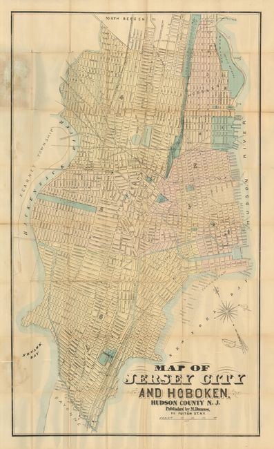
"Map of Jersey City and Hoboken, Hudson County, N.J.", Dripps, Matthew

Subject: New Jersey

Period: 1895 (circa)

Publication:

Color: Hand Color

Size:
21 x 35.5 inches
53.3 x 90.2 cm
Download High Resolution Image
(or just click on image to launch the Zoom viewer)

Rare, pocket map of Jersey City showing the streets, railroads and city docks. It is colored by ward with the city parks, cemeteries and public buildings also highlighted. Ellis and Bedloe's Islands, along with the Statue of Liberty, are shown in New York Harbor. The map folds into the original, cloth-covered and embossed boards. A pasted-down advertisement inside the front cover lists Dripps' other maps of the vicinity with their prices. Matthew Dripps, an Irish immigrant, published maps of the vicinity of New York City in the latter part of the 19th century. He was instrumental in publishing detailed urban maps that are notable for their distillation of information. We can find no records of this map, either in price records or institutional collections.

References:

Condition: C

There are several clean fold separations, which need repair. Otherwise the map is complete, generally clean with a few minor stains, and the covers are in fine condition.

Estimate: $200 - $300

Sold for: $150

Closed on 9/23/2009

Archived