Catalog Archive
Auction 129, Lot 197

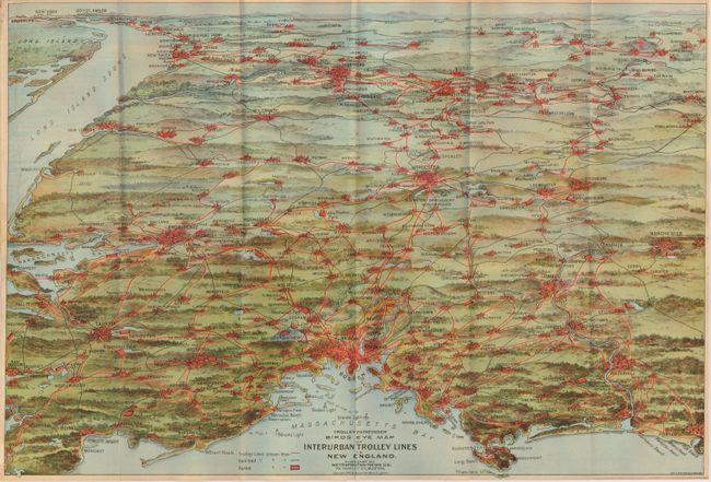
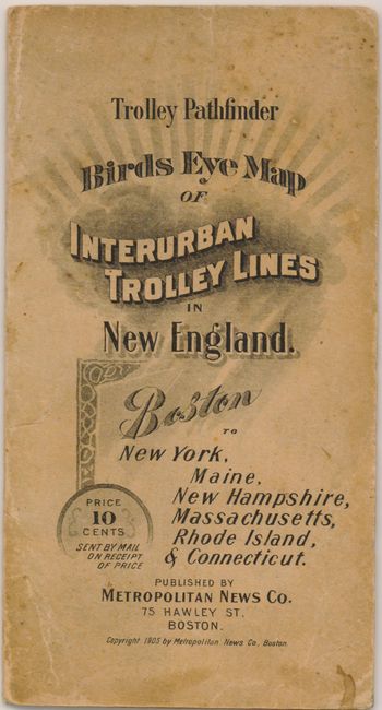
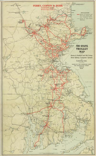
"[Lot of 2] Trolley Pathfinder. Birds Eye Map of Interurban Trolley Lines [and] Tri-State Trolley Map",

Subject: New England

Period: 1905-07 (dated)

Publication:

Color: Printed Color

Size:
See Description
Download High Resolution Image
(or just click on image to launch the Zoom viewer)

1) Trolley Pathfinder. Birds Eye Map of Interurban Trolley Lines. This is a scarce and very colorful bird's-eye view of eastern New England with the trolley lines highlighted in red overprinting presented in pocket map format. It shows Boston at lower middle with Portsmouth, Plymouth, Kingston, and Rockport in the foreground. On the far horizon are Long Island Sound, New York City, Danbury, Hartford, Springfield and Williamston. Also locates the towns of Providence, Worchester, Manchester, Lowell and many more. Legend identifies Trolley Lines, Railroads, and Parks. This version's verso is blank. Folds into softly engraved covers (4 x 7.5) with graphics and a sun-burst. Published by the Metropolitan News Co., and printed by Walker, George H. & Co., both of Boston. Dated 1905, 20" x 14", printed color. Back cover with advertisements, inside cover is list of all railroads and trolleys in the region. Map is very nice with great color (B+), the covers are soiled and the back cover has a tear closed by an old repair. This is an early example of similar maps variously published from Boston.

2) Tri-State Trolley Map. This pocket map is a great promotional map detailing the region to include Massachusetts, Rhode Island, and New Hampshire with Boston shown at the center. Red overprinting indicates the map was presented by the firm of Perry, Coffin & Burr, Investment Bonds, 60 State St., Boston. Red overprinting is also used to boldly indicate the extensive network of the Boston & Northern and Old Colony Street Railway companies, with other Street Railways shown via smaller black lines. The map extends to include Newport, Rhode Island and as far north as Concord, New Hampshire. Blank verso. Folds to 4" x 7". Engraved by J.C. Peters & Son, and published by the Boston & Northern and Old Colony Street Railway Companies, both of Boston. This pocket map is missing its paper cover, but the map is very nice with a few short marginal splits along folds (B+).

References:

Condition:

See individual descriptions.

Estimate: $190 - $240

Sold for: $140

Closed on 9/23/2009

Archived