Catalog Archive
Auction 127, Lot 671

"Asia recens summa cura delineata", Hondius/Jansson
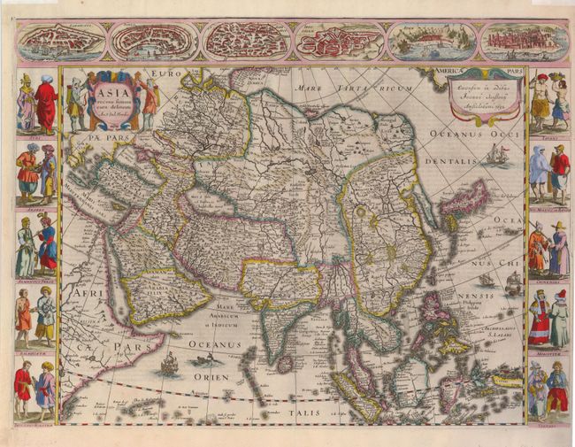
Subject: Asia

Period: 1632 (dated)

Publication:

Color: Hand Color

Size:
22 x 16 inches
55.9 x 40.6 cm
Download High Resolution Image
(or just click on image to launch the Zoom viewer)

This superb map was first issued in 1623, in response to fierce competition with the Blaeu family whose own carte-a-figures map of Asia was published in 1617. The map conforms to the Blaeu model in most respects, except in the delineation of the northeastern coastline of Asia, which does not extend in to the Arctic. The map extends from the Arabian peninsula through the East Indies. There is a wide expanse of ocean between the east coast of Asia and America, which is conveniently hidden by Jansson's signature cartouche. Korea is shown as a long peninsula and Japan is based on the Ortelius/Teixeira model. The upper border features town plans of the eastern Mediterranean and Middle East and at sides are panels showing various costumes of people throughout the continent. Two hunters flank the title cartouche and the sheet is embellished with European ships, a Chinese sampan and a sea monster. German text on verso. The carte-a-figures version of this map is rare because a new smaller map without the borders, prepared by Henricus Hondius and Jan Jansson in 1631, replaced it in most editions of the Mercator/Hondius atlases.

References: Yeo #25; Tibbetts #83.

Condition: A+

Remnants of hinge tape at top edge of margin.

Estimate: $4,000 - $5,000

Sold for: $3,000

Closed on 2/25/2009

Archived