Catalog Archive
Auction 127, Lot 496

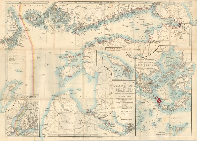
"The Gulf of Finland and Baltic Sea with the Fortified Places from Stockholm to St. Petersburg … Designed to Show the Operations of the British & French Fleets", Wyld, James

Subject: Baltic

Period: 1855 (dated)

Publication:

Color: Hand Color

Size:
27 x 18.8 inches
68.6 x 47.8 cm
Download High Resolution Image
(or just click on image to launch the Zoom viewer)

Uncommon pocket map of the Baltic area naming St. Petersburg, the Gulf of Finland, and Riga. The map is highly detailed and surrounded by four large insets: "The Harbour & Entrances of Sweaborg and Helsingfors with the Fortifications & Batteries;" "Cronstadt and St. Petersburg from Russian Surveys;" "Cronstadt with the Fortifications & Batteries;" and the "Gulf of Bothnia." Map is linen-backed, folds into cloth covers, (4.5 x 7") titled "Wyld's Map of the Baltic, Gulf of Finland." Map has a paper label on linen side with Wyld's List of Recent Publications. Map is dated May 7th, 1855.

References:

Condition: B+

Map is very nice with just a couple of light spots. Covers are somewhat rubbed and spine is sunned. Owner's name in ink on blank inside cover, dated 1855.

Estimate: $140 - $180

Sold for: $70

Closed on 2/25/2009

Archived