Catalog Archive
Auction 127, Lot 346

"Die Amerikanische Staats-Domane (National Park) im Quellgediete des Yellowstone Flusses mit den Geyser-Gebieten", Petermann, Augustus Herman

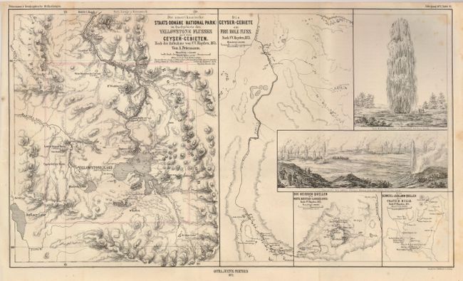
Subject: Wyoming, Yellowstone National Park

Period: 1872 (dated)

Publication: Geographische Mittheilung

Color: Black & White

Size:
16.7 x 9.7 inches
42.4 x 24.6 cm
Download High Resolution Image
(or just click on image to launch the Zoom viewer)

This map was issued in the same year Yellowstone National Park was created, making it one of the earliest possible maps to show the park. It contains views of two geysers and four maps. The main map (8" x 9.7") is titled as given above. The map shows the entire newly created National Park with great topographical detail shown in hachure, with a little original outline color along the park's boundary. The second map "Die Geyser-Gebiete am Fire Hold Fluss Nach F.V. Hayden, 1871" uses small dots to indicate the location of scores of geysers along the Fire Hole River. Most of the geysers are unnamed, but Old Faithful is one that is named. The other two maps are small insets of White Mountain (Gardiner River), and Crater Hills, both after Hayden. One view shows the Giant Geyser at full eruption. The other is a wide view of the geyser basin with all geysers erupting simultaneously as if by magic.

References:

Condition: B+

Folding as issued. A few light spots, mostly at right, otherwise very good to fine.

Estimate: $100 - $140

Sold for: $190

Closed on 2/25/2009

Archived