Catalog Archive
Auction 127, Lot 216

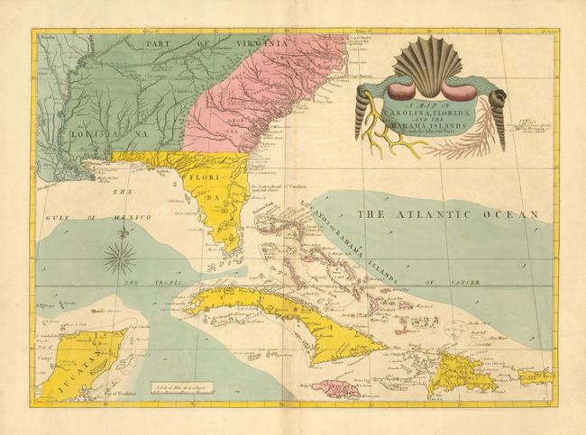
"A Map of Carolina, Florida and the Bahama Islands with the Adjacent Parts", Catesby, Mark

Subject: Colonial Southeast and Bahamas

Period: 1815 (circa)

Publication: The Natural History of Carolina, Florida and Bahama Islands

Color: Hand Color

Size:
24 x 17 inches
61 x 43.2 cm
Download High Resolution Image
(or just click on image to launch the Zoom viewer)

This rare map was published in the first natural history of American flora and fauna. It shows the area from just beyond the Mississippi River to Cape Charles in the north, and in the south from the Yucatan Peninsula through Cuba and the Bahamas to Puerto Rico. It is among the earliest maps on which Georgia appears. The map is based in part on John Barnwell's manuscript map of circa 1722 and presents a great deal of information on the location of French, Spanish, Indian and English settlements and details not found on earlier printed maps. It also derives from Henry Popple's great map of 1733. Like the delightful drawings that appeared in Catesby's work, the striking title cartouche is composed of shells and coral.

This is the second state of the map with the color scheme altered to show the political changes of the Treaty of Paris in 1763. On the first state (1733-54), French Louisiana, on both sides of the Mississippi, was colored green. On the second state (1771-c.1815), the territory east of the Mississippi is colored green showing the part of Louisiana that had been acquired by Britain; the territory to the west, which now belonged to Spain, is colored blue. This example is from the edition published in the early part of the nineteenth century with the watermark - J Whatman 1815. The English versions of this map, in any edition, rarely appear on the market.

References: Cumming (SE) #210; Schwartz & Ehrenberg pp. 151-21.

Condition: B+

Fine original color with a hint of very faint foxing.

Estimate: $6,500 - $8,000

Sold for: $4,750

Closed on 2/25/2009

Archived