Catalog Archive
Auction 127, Lot 210

"Map of the Texas & Pacific Railway and Connections", Railroad Companies, (Various)

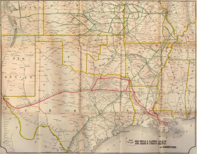
Subject: South-central United States

Period: 1901 (dated)

Publication: Annual Report of the Directors of the Texas and Pacific Railway

Color: Printed Color

Size:
22.8 x 17.8 inches
57.9 x 45.2 cm
Download High Resolution Image
(or just click on image to launch the Zoom viewer)

This large folding map uses red overprinting to detail the rail line between New Orleans, Shreveport, Dallas, Fort Worth and terminating in El Paso. We have previously had the 1900 edition, which makes an interesting comparison to this 1901 edition. Additional miles of rail are evident between Shreveport and Texarkana and in a few more areas. A loop line travels from Marshall to Texarkana to Sherman and then south to Fort Worth. A few short spur lines are delineated including to Thibodeaux and Marksville. Centered on Texas, the extensive rail system spreads throughout much of Louisiana, Arkansas, Indian Territory, Oklahoma, Missouri, Kansas and Colorado. Each railroad is named and identified with overprinted color; the Texas & Pacific, San Antonio Div. Int. & Gt. Nor. Gulf railroads and several more, with all rail stations named. Connections continue to Pueblo, Wichita, Kansas City, St. Louis, Memphis, and New Orleans, to mention a few. There is good detail of towns and wagon roads of the day. Bound into original 56-page report "Annual Report of the Directors of the Texas and Pacific Railway Co. to the Stockholders for the Fiscal Year Ending December 31st, 1901."

References:

Condition: A

Map is fine less a little toning at extreme left edge where pasted into report. The report is disbound, signatures tight and contents fine.

Estimate: $250 - $350

Sold for: $190

Closed on 2/25/2009

Archived