Catalog Archive
Auction 127, Lot 193

"Virginia - Erforshet und Beschriben durch Capitain Iohan Schmidt", Merian, Matthaus

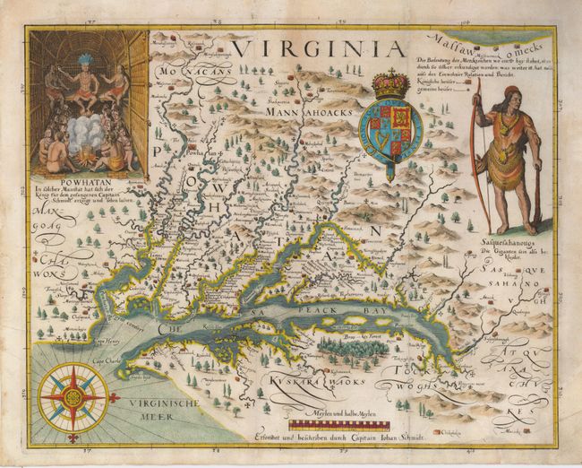
Subject: Colonial Mid-Atlantic

Period: 1627 (published)

Publication: Grand Voyages, Part XIII

Color: Hand Color

Size:
14 x 11.3 inches
35.6 x 28.7 cm
Download High Resolution Image
(or just click on image to launch the Zoom viewer)

John Smith's map was the most important map of Virginia and Chesapeake Bay of the seventeenth century. It was the prototype map of the region and was instrumental in creating interest in the new Virginia colony. The map depicts a number of explorations and observations made by Smith and the Jamestown settlers, with small crosses marking the range of those explorations. The information on the locations of the Indian tribes and villages is very extensive; in fact it is still in use by archaeologists today. The decorations are based on John White's drawings made during the first attempt to form a colony in Virginia, as published in the first part of Theodore de Bry's Grand Voyages. This third derivative of Smith's map accompanied the 13th part of the Grand Voyages, which was published posthumously by his son-in-law, Mathaus Merian.

References: Burden #219; Tooley (Amer) p. 163-4 #3, plt 71; Garratt (TMC-9) p. 9, #G39.

Condition: B+

The map is professionally backed with light Japanese tissue repairing a couple of short tears into the map at bottom right and entering the map at top, between the V and I in the title. The repairs are nearly invisible and expertly done.

Estimate: $5,500 - $6,500

Sold for: $5,500

Closed on 2/25/2009

Archived