Catalog Archive
Auction 126, Lot 81

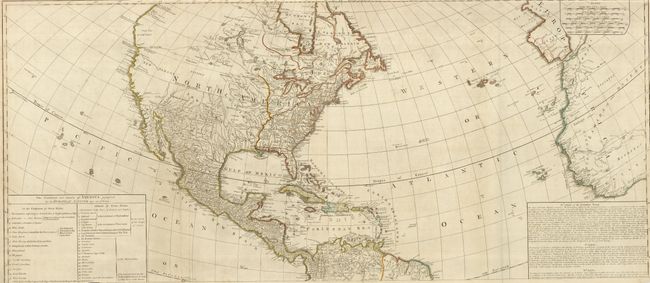
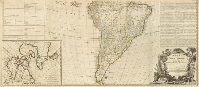
"A New Map of the Whole Continent of America Divided into North and South and West Indies…", Sayer & Bennett

Subject: Western Hemisphere

Period: 1777 (dated)

Publication:

Color: Hand Color

Size:
46.8 x 20.5 inches
118.9 x 52.1 cm
Download High Resolution Image
(or just click on image to launch the Zoom viewer)

An impressive, large map of North and South America, originally drawn by John Gibson in 1763 with a slightly different title. The map went through several revisions; this is the third state. The huge map is filled with incredible detail and is based on D'Anville's cartography, as well as Spanish explorations on the west coast of North America and the journals of Governor Pownall in New England and Canada. The British colonies are shown with the western boundary on the Mississippi and Ohio Rivers. This issue includes Fort Detroit located at the southern end of the Lake St. Clair, which has been considerably altered in shape from previous editions. In the west are two possible locations for a River of the West; one with its source at Pike's Lake, the other further north at Lake Winnipeg. A Chinese colony, Fou Sang is shown in present-day British Columbia, just north of a notation concerning the Sea of the West. At lower left is an inset map of Hudson and Baffin's Bay. Above the inset is a large text panel listing of the Articles of the Treaty of Paris of 1763. The baroque-style title cartouche features a beaver, a crocodile and an Indian headdress amid trees, a waterfall and tropical flora. Printed on four sheets (joined to form two pairs) as issued. The map would measure 46.8 x 40.5" if joined.

References: Tooley (Amer) p. 51, #3c; Stevens & Tree #3c.

Condition: B

Original outline color. Narrow (1/8") top margin with one tiny chip into the border. There is a tear into the table at left in the top sheet that is closed on verso with paper tape, and one short fold separation.

Estimate: $1,400 - $1,800

Sold for: $1,000

Closed on 12/3/2008

Archived