Catalog Archive
Auction 126, Lot 49

"Chart of the Antarctic Continent Shewing the Icy Barrier Attached to it. Discovered by the U.S.Ex.Ex.", Wilkes, Charles
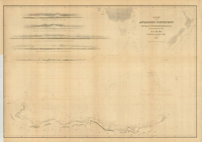
Subject: South Pole

Period: 1840 (dated)

Publication: Atlas...of the United States Exploring Expedition...1838, 1839, 1840, 1841, 1842

Color: Black & White

Size:
34.3 x 23.5 inches
87.1 x 59.7 cm
Download High Resolution Image
(or just click on image to launch the Zoom viewer)

This large format chart is from the first trade edition of the rare Wilkes Expedition Atlas. The map represented a major advance in establishing Antarctica as a true continent thus helping to settle the cartographic mystery of its existence which had been debated by explorers and mapmakers for centuries. It is a detailed map of Antarctica and the southern Pacific Ocean centered on the longitude of Van Diemens Land. It shows Antarctica from about longitude 95° West to 170° with surprisingly good detail along the coastline; locates Repulse Bay, Porpoise Bay, Piners Bay, Disappointment Bay, Cape Hudson, and Peacocks Bay plus Knox's, Budd's, Totten's and North's Highlands. Also names Point Alden, Point Case, Point Emmons and more. Numerous Ice Islands clog the bays and seas near land and many air and water temperatures are noted. The tracks of the ships Vincennes, Peacock, Porpoise, and Flying Fish are detailed. At upper left are five sea approach views. An important chart which should be in any Antarctic collection.

References: Rumsey #4442.

Condition: B

Most folds are a little weak with some marginal splits. Toned and a little offsetting from title.

Estimate: $300 - $500

Sold for: $230

Closed on 12/3/2008

Archived