Catalog Archive
Auction 126, Lot 348

"Map of the Vicinity of Richmond, and Part of the Peninsula. From Surveys Made by the Order of Maj. Gen. J. F. Gilmer Chief Engineer, C.S.A.", Gilmer, Jeremy Francis

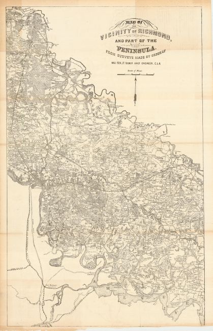
Subject: Virginia, Civil War

Period: 1862-63 (circa)

Publication:

Color: Black & White

Size:
16.5 x 27 inches
41.9 x 68.6 cm
Download High Resolution Image
(or just click on image to launch the Zoom viewer)

This rare map was published from Richmond by the Confederacy. It is a variant of the Campbell map (Map of the Vicinity of Richmond and Part of the Peninsula), of which the sole known example resides in the Hargett Library at the University of Georgia. The Campbell map and this Gilmer version includes a backwards N and S in the north arrow, but the version published in the Atlas To Accompany The Official Records Of The Union And Confederate Armies does not. The dimensions between the two are identical. The notes on the Campbell map and these similarities suggest both were probably engraved and printed in Richmond at about the same time. The soft lithography used also indicates this is a C.S.A. publication.

The production of maps for the Confederate Army was difficult, particularily at first. The Library of Congress says "The Confederate Army had difficulty throughout the war in supplying its field officers with adequate maps. The situation in the South was acute from the beginning of hostilities because of the lack of established government mapping agencies capable of preparing large-scale maps, and the inadequacy of reprinting facilities for producing them. The situation was further complicated by the almost total absence of surveying and drafting equipment, and the lack of trained military engineers and mapmakers to use the equipment that was available."

The map shows the region bounded on the north by Hanover Junction and the North Anna River, on the east by the Pamunkey River and in the south by the James River well below Richmond. The map extends with less detail to Petersburg. Locates hundreds of individual land holdings each identified by name, wagon roads and tails, churches, and much more. The railroads named are the City Point, Clover Hill, Richmond and Petersburg, and three other unnamed rails originating from Richmond and travelling north and east. In all a remarkably detailed campaign map that is drawn on a scale of about 1.6 miles per inch.

The map was surveyed and drawn under the direction of Jeremy Francis Gilmer, Chief Engineeer, C.S.A. Gilmer had been a United States Army Engineer from 1839 until the beginning of the conflict when he entered the Confederate Army. He was appointed Major of Engineers and eventually reached the rank of Major General. After the war, he was a director for the Georgia Central Railroad and then president of the Savannah Gas-Light Company.

References:

Condition: B+

Folding as issued. Close margin at bottom as issed. Some toning along top edge, but in general a fine example of this rare issue.

Estimate: $700 - $800

Sold for: $850

Closed on 12/3/2008

Archived