Catalog Archive
Auction 126, Lot 307

"Sketch of the Yellowstone Lake and the Valley of the Upper Yellowstone River. Route of Capt's J.W. Barlow and D.P. Heap, Corps of Engineers, in the Reconnaissance of that Region during the Summer of 1871.", U.S. War Department

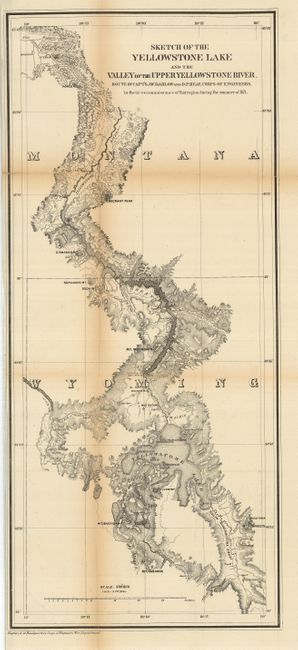
Subject: Montana, Wyoming, Yellowstone Park

Period: 1872 (published)

Publication: Sen. Ex. Doc. 66, 42nd Congress, 2nd Session

Color: Black & White

Size:
12 x 27.5 inches
30.5 x 69.9 cm
Download High Resolution Image
(or just click on image to launch the Zoom viewer)

This map is from Barlow and Heap's "Letter from the Secretary of War, Accompanying an Engineering Report of a Reconnaissance of the Yellowstone River in 1871." The captains were dispatched by Lieut. General Sheridan to investigate the reports of extraordinary phenomena in the Yellowstone region. They entered the area that would become Yellowstone National Park in July 1871 under the same military escort provided for the Hayden party. After splitting from the main group, the expedition visited Tower Falls, Mount Washburn, the lower and upper falls of the Yellowstone River, Mud Volcano, Yellowstone Lake, and numerous geyser basins. They then proceeded southward to explore the basins of the upper Snake and Yellowstone Rivers, the first detailed exploration of these areas since the 1830's. The map details the routes traveled and camp sites with dates. There is detailed topography, watershed and landmarks. Blevins comments that Barlow and Heaps's "map provides the first detail of many areas of the park as the Hayden maps based upon his 1872 survey would not be published until 1873." An important map which should be in any Yellowstone collection. We find no past sales records for this scarce issue.

References: Blevins 225; Wheat 1220.

Condition: B+

Beautiful, dark impression. Toned along folds with archival tape on verso to support folds.

Estimate: $250 - $300

Sold for: $210

Closed on 12/3/2008

Archived