Catalog Archive
Auction 125, Lot 97

"L'Amerique Septentrionale Dressee sur les Observations de Mrs. de l'Academie Royale des Sciences…", Delisle/Schenk

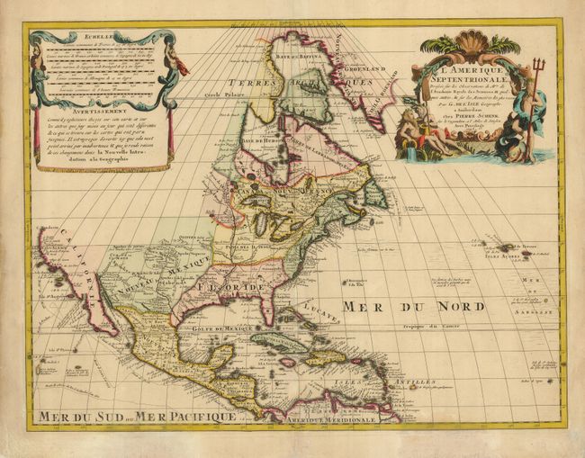
Subject: North America

Period: 1708 (dated)

Publication: Atlas Maior cum Generales Omnium Totius Orbis…

Color: Hand Color

Size:
23.3 x 17.5 inches
59.2 x 44.5 cm
Download High Resolution Image
(or just click on image to launch the Zoom viewer)

This is Pierre Schenk version of Delisle's foundation map of North America. It is nearly identical to the Delisle map, with California returned to its peninsular shape rather than as an island. C. Mendocin is the farthest northern point in California, beyond which no conjectural geographical detail is presented. In the Southwest, a mountain-ringed valley named Valle de los Corozones appears, based on the early reports of Alvar Nuñez Cabeza de Vaca. The Great Lakes are well-defined, based on Coronelli with French forts noted. The English settlements are confined east of the Alleghenies and several French forts and settlements are depicted in the Mississippi River valley. Several explorations are traced in the Pacific and the Sargasso Sea is prominently shown in the North Atlantic. The map is decorated with an aquatic-themed figural cartouche and a draped scale of miles.

References: Tooley (Amer) p.19.

Condition: B+

Sharp impression and lovely old color. Some discoloration at bottom and some paper repairs in the blank margins.

Estimate: $1,200 - $1,500

Sold for: $1,900

Closed on 9/24/2008

Archived