Catalog Archive
Auction 125, Lot 837

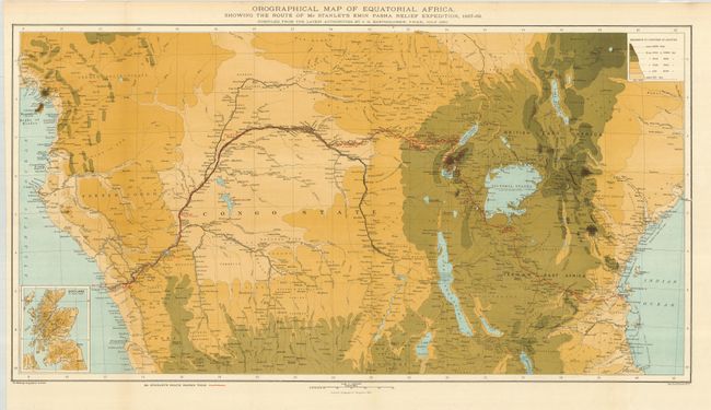
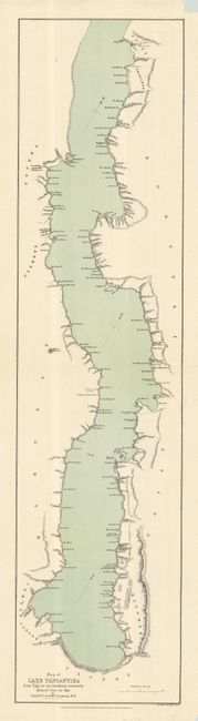
"[Lot of 2] Orographical Map of Equatorial Africa… [and] Map of Lake Tanganyika from Ujiji to its Southern Extremity…",

Subject: Central Africa

Period: 1875-90 (dated)

Publication:

Color: Printed Color

Size:
See Description
Download High Resolution Image
(or just click on image to launch the Zoom viewer)

European exploration of Central Africa did not take place until the 19th century. The national geographical societies of Europe published journals of explorers' accounts and also organized and financed major expeditions to Africa. Among the most preeminent explorers in Central Africa were David Livingston, Verney Lovett Cameron, and Henry Morton Stanley. This lot contains two maps from this important period in the mapping of Africa.

1) Orographical Map of Equatorial Africa… (27.5 x 14.5") by John George Bartholomew for the Scottish Geographical Magazine, 1890. This unusual map features the physical geography of the mountains and mountain ranges in the region. A red line traces the route of Henry Morton Stanley's expedition to rescue the Emin Pasha in 1887-89. On this expedition Stanley discovered the Ruwenzori Range, the legendary Mountains of the Moon that were the supposed source of the Nile, and confirmed that its watershed did feed the White Nile. He also explored the land south of Lake Albert and named Albert Edward Nyanza after Britain's Prince of Wales (now simply called Lake Edward). The map features a small inset of Scotland on the same scale to visually remind the reader of the vast size of the heart of Africa.

2) Map of Lake Tanganyika from Ujiji to its Southern Extremity… (7 x 29") by John Murray for the Royal Geographical Society, 1875. This detailed map of Lake Tanganyika was reduced from a map by Lt. Verney Lovett Cameron, a pioneer explorer of Africa who took part in the search for Livingston. Cameron mapped this important lake and solved the question of its outlet, discovering the Lukuga River. After tracing the Congo-Zambezi watershed for hundreds of miles he reached Bihe and finally arrived at the coast, being the first European to cross Equatorial Africa from sea to sea.

References:

Condition:

1) Issued folding, now nicely flattened with mounting tape remnants on verso, A+. 2) Small paper loss in upper blank margin and a tear entering 1/2" in the map at left, repaired with archival tape, B.

Estimate: $300 - $400

Sold for: $220

Closed on 9/24/2008

Archived